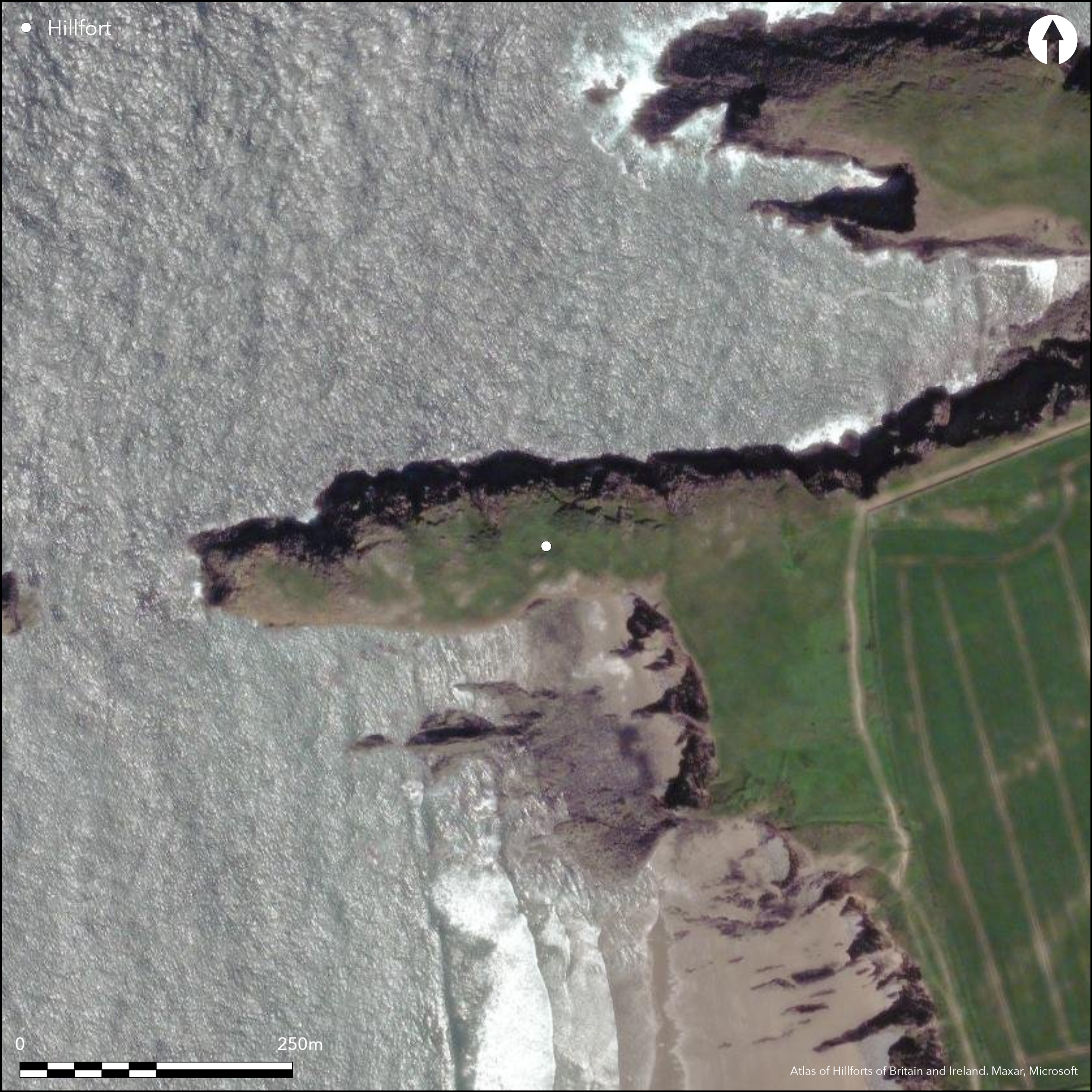
Satellite Imagery
Satellite Imagery
HER: Dyfed 2844 (None)
NMR: SM 83 SW (309560)
SM: PE549(PEM)
NGR: SM80093226
X: 180090 Y: 232260 (OSGB36)
Coastal promontory fort located on long and sharp W-facing promontory jutting into sea immediately to S of Porth Egr, and N of Culporth, bays on N coast of county. Separate islet in sea to W suggests site possibly longer in prehistory. High 30m sea cliffs to N, S and W, level to gently rising slope to E. Interior c. 200m E-W by c. 60m, with area estimated at 1.2ha. Natural fissures in the rock make identification difficult, and only recognised as a fort by DAT comparatively recently. It is possible that these natural features were incorporated in defences, but definite rampart of earth and stones with ditch cuts off the promontory on E for c. three-quarters across for c. 20m, bank 4m across and to c. 0.6m high. Bank spread at N end. This ends well short of the cliff edge on the S, suggesting site possibly unfinished. RCAHMW (Coflein) suggest from aerial photographs that there are three lines of defence. Outer and middle banks set parallel and cut across promontory at right angles to the cliff. Inner rampart at a diagonal, with possible ditch or quarry pits placed on inner edge; possibly phased construction. No entrance defined. Under coastal grassland. Minimal investigations, undated.
Citizen Science: ✗
Reliability of Data: Confirmed
Reliability of Interpretation: Confirmed
X: -578997 Y: 6790227 (EPSG: 3857)
Longitude: -5.201215225420199 Latitude: 51.94522173976284 (EPSG:4326)
Country: Wales
Current County or Unitary Authority: Pembrokeshire
Historic County: Pembrokeshire
Current Parish/Community/Council/Townland: Llanrhian
Pembrokeshire Coast Path runs to E. Natural fissures in the rock make identification difficult, and only recognised as a fort by DAT comparatively recently.
| Extant | ✓ |
| Cropmark | ✗ |
| Likely Destroyed | ✗ |
Under coastal grassland with bare rock.
| Woodland | ✗ |
| Commercial Forestry Plantation | ✗ |
| Parkland | ✗ |
| Pasture (Grazing) | ✗ |
| Arable | ✗ |
| Scrub/Bracken | ✗ |
| Bare Outcrop | ✗ |
| Heather/Moorland | ✗ |
| Heath | ✗ |
| Built-up | ✗ |
| Coastal Grassland | ✓ |
| Other | ✗ |
Coastal promontory fort located on long and sharp W-facing promontory jutting into sea immediately to S of Porth Egr, and N of Culporth, bays on N coast of county. Separate islet in sea to W suggests possibly longer in prehistory. High 30m sea cliffs to N, S and W, level to gently rising slope to E.
| Contour Fort | ✗ |
| Partial Contour Fort | ✗ |
| Promontory Fort | ✓ |
| Hillslope Fort | ✗ |
| Level Terrain Fort | ✗ |
| Marsh Fort | ✗ |
| Multiple Enclosure Fort | ✗ |
| Hilltop | ✗ |
| Coastal Promontory | ✓ |
| Inland Promontory | ✗ |
| Valley Bottom | ✗ |
| Knoll/Hillock/Outcrop | ✗ |
| Ridge | ✗ |
| Cliff/Plateau-edge/Scarp | ✗ |
| Hillslope | ✗ |
| Lowland | ✗ |
| Spur | ✗ |
Dominant Topographic Feature: Coastal headland
| North | ✗ |
| Northeast | ✗ |
| East | ✗ |
| Southeast | ✗ |
| South | ✗ |
| Southwest | ✗ |
| West | ✓ |
| Northwest | ✗ |
| Level | ✗ |
Altitude: 31.0m
N/A
None
Reliability: D - None
| Pre 1200BC | ✗ |
| 1200BC - 800BC | ✗ |
| 800BC - 400BC | ✗ |
| 400BC - AD50 | ✗ |
| AD50 - AD400 | ✗ |
| AD400 - AD 800 | ✗ |
| Post AD800 | ✗ |
| Unknown | ✓ |
| Pre Hillfort: | None |
| Post Hillfort: | None |
Field Observation OS 1966. Field Observation NT 1989 . Field Observation DAT 1994,1996 ,2006. Cambria Archaeology defended enclosures survey 2006-2007.
| Other (1966): | Field Observation OS. |
| Other (1989): | Field Observation NT. |
| Other (None): | Field Observation DAT. |
| Other (None): | Cambria Archaeology defended enclosures survey. |
If inner rampart exists, possible ditch or quarry pits placed on inner edge suggested by RCAHMW (Cofllein).
None
| None | ✓ |
| Spring | ✗ |
| Stream | ✗ |
| Pool | ✗ |
| Flush | ✗ |
| Well | ✗ |
| Other | ✗ |
If inner rampart exists, possible ditch or quarry pits placed on inner edge.
| No Known Features | ✗ |
| Round Stone Structures | ✗ |
| Rectangular Stone Structures | ✗ |
| Curvilinear Platforms | ✗ |
| Other Roundhouse Evidence | ✗ |
| Pits | ✗ |
| Quarry Hollows | ✓ |
| Other | ✓ |
None
| No Known Excavation | ✓ |
| Pits | ✗ |
| Postholes | ✗ |
| Roundhouses | ✗ |
| Rectangular Structures | ✗ |
| Roads/Tracks | ✗ |
| Quarry Hollows | ✗ |
| Other | ✗ |
| Nothing Found | ✗ |
None
| No Known Geophysics | ✓ |
| Pits | ✗ |
| Roundhouses | ✗ |
| Rectangular Structures | ✗ |
| Roads/Tracks | ✗ |
| Quarry Hollows | ✗ |
| Other | ✗ |
| Nothing Found | ✗ |
None
| No Known Finds | ✓ |
| Pottery | ✗ |
| Metal | ✗ |
| Metalworking | ✗ |
| Human Bones | ✗ |
| Animal Bones | ✗ |
| Lithics | ✗ |
| Environmental | ✗ |
| Other | ✗ |
If inner rampart exists, possible ditch or quarry pits placed on inner edge suggested by RCAHMW (Coflein).
| APs Not Checked | ✗ |
| None | ✗ |
| Roundhouses | ✗ |
| Rectangular Structures | ✗ |
| Pits | ✗ |
| Postholes | ✗ |
| Roads/Tracks | ✗ |
| Other | ✓ |
None defined.
| 0: | None |
| 2: | None |
Guard Chambers: ✗
Chevaux de Frise: ✗
Rampart of earth and stones with ditch cuts off the promontory on E for c. three-quarters across for c. 20m, bank 4m across and to c. 0.6m high. Bank spread at N end. This ends well short of the cliff edge on the S, suggesting site possibly unfinished. RCAHMW (Coflein) suggest from aerial photographs that there are three lines of defence. Outer and middle banks set parallel and cut across promontory at right angles to the cliff. Inner rampart at a diagonal, with possible ditch or quarry pits placed on inner edge; possibly phased construction.
| Area 1: | 1.2ha. |
| Total: | 1.2ha. |
Total Footprint Area: Noneha.
None
| ✓ | Inner rampart at a diagonal, with possible ditch or quarry pits placed on inner edge; possibly phased construction suggested by RCAHMW (Coflein), but not proven. |
| ✗ | RCAHMW (Coflein) suggest from aerial photographs that there are three lines of defence. Outer and middle banks set parallel and cut across promontory at right angles to the cliff. Inner rampart at a diagonal, with possible ditch or quarry pits placed on inner edge. |
| NE Quadrant: | 3 |
| SE Quadrant: | 3 |
| SW Quadrant: | 0 |
| NW Quadrant: | 0 |
| Total: | 3 |
| Partial Univallate | ✗ |
| Univallate | ✗ |
| Partial Bivallate | ✗ |
| Bivallate | ✗ |
| Partial Multivallate | ✓ |
| Multivallate | ✗ |
| Unknown | ✗ |
| Partial Univallate | ✗ |
| Univallate | ✗ |
| Partial Bivallate | ✗ |
| Bivallate | ✗ |
| Partial Multivallate | ✗ |
| Multivallate | ✗ |
Earth and stone rampart. Bank spread at N end. This ends well short of the cliff edge on the S, suggesting site possibly unfinished.
| None | ✗ |
| Earthen Bank | ✓ |
| Stone Wall | ✗ |
| Rubble | ✓ |
| Wall-walk | ✗ |
| Evidence of Timber | ✗ |
| Vitrification | ✗ |
| Other Burning | ✗ |
| Palisade | ✗ |
| Counter Scarp Bank | ✗ |
| Berm | ✗ |
| Unfinished | ✓ |
| Other | ✗ |
None
| None | ✗ |
| Earthen Bank | ✗ |
| Stone Wall | ✗ |
| Murus Duplex | ✗ |
| Timber-framed | ✗ |
| Timber-laced | ✗ |
| Vitrification | ✗ |
| Other Burning | ✗ |
| Palisade | ✗ |
| Counter Scarp Bank | ✗ |
| Berm | ✗ |
| Unfinished | ✗ |
| No Known Excavation | ✓ |
| Other | ✗ |
| ✗ | None |
| ✓ | Definite one, but actual number not defined if three lines of rampart. |
Number of Ditches: 1
| ✗ | None |
Driver, T. 2007. Pembrokeshire, Historic Landscapes from the Air, Aberystwyth: RCAHMW, 32.
Murphy, K., Ramsey, R., Poucher, P. and Page, M. 2007. A Survey of Defended Enclosures in Pembrokeshire, 2006-2007: Gazetteer of Ordnance Survey Grid Squares SM73, SM83 and and SM93, Cambria Archaeology Report No. 2007/01, Project Record No. 54269, Llandeilo: Cambria Archaeology.
Atlas of Hillforts:
Wikidata:
This work is licensed under CC BY-SA 4.0

 and should be cited as:
Lock, Gary and Ralston, Ian. 2024. Atlas of Hillforts of Britain and Ireland. Available at: https://hillforts.arch.ox.ac.uk
Document Version 1.1