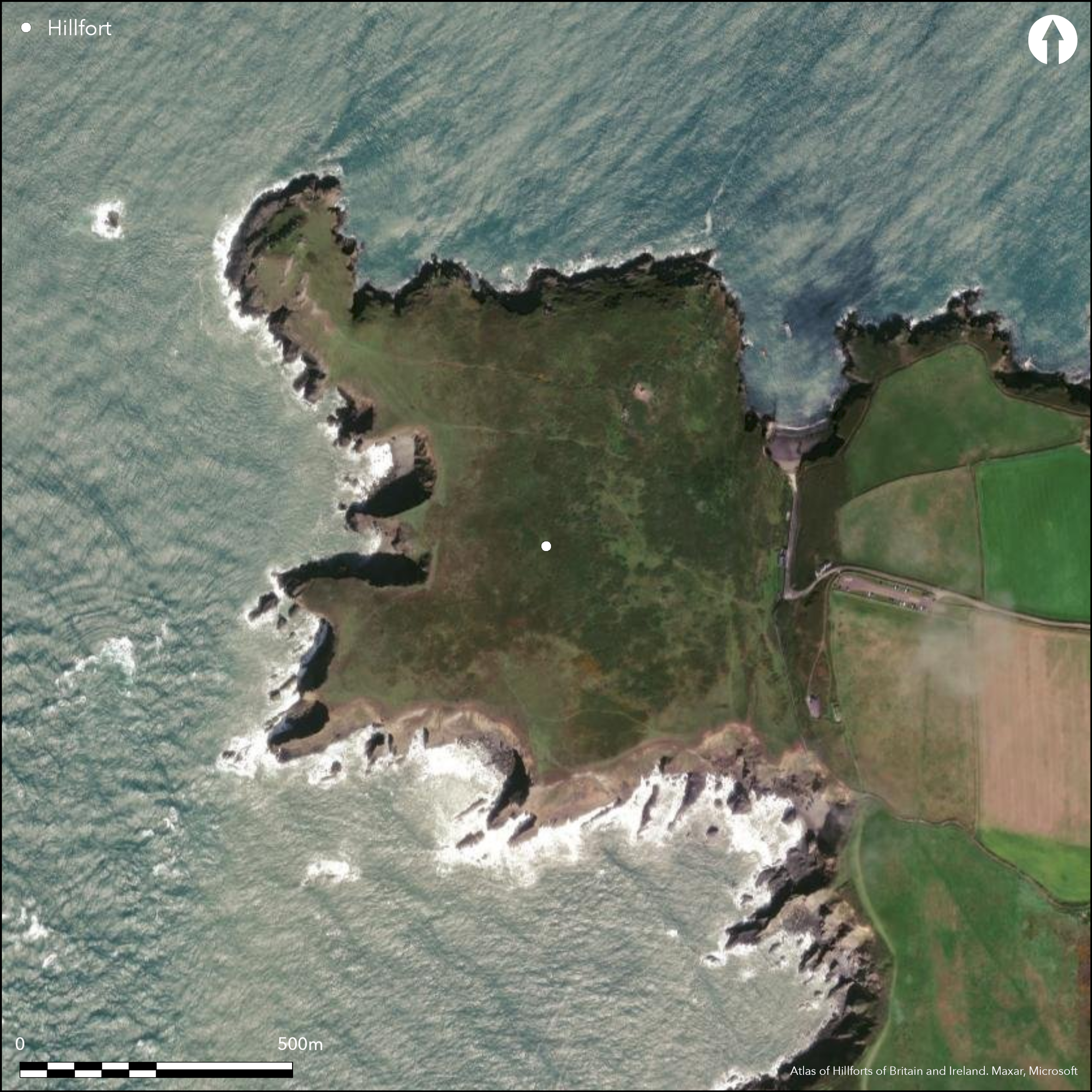
Satellite Imagery
Satellite Imagery
HER: Dyfed 2940 (None)
NMR: SM 70 NE (95061)
SM: PE323(PEM)
NGR: SM 7577 0905
X: 175770 Y: 209050 (OSGB36)
Very large, at 22ha, coastal promontory fort located on prominent N-facing headland opposite Skomer Island. Sea cliffs to N, S and W, level landward through neck of promontory on SE. One of largest forts in Wales. Earthen rampart with periodic ditch, c. 268m long, cuts across lip of N-S valley that separates the promontory plateau from landward. This merges with natural slopes to N. Access was at upper S end of the valley with two entrances, one, slightly inturned, c. 65m from the S cliffs, the second, immediately N of the cliff, opening onto small, roughly rectangular enclosure c. 72m N-S by 32m. Field banks and cultivation ridges in interior to SW and N side. RCAHMW aerial reconnaisance 2011 identified promontory enclosure on NW-rocky promontory within larger fort of uncertain date. Possibly later the fort was adapted as a park pale. Coastal grassland and some scrub. On 1st Ed. OS map (1875). Undated.
Citizen Science: ✗
Reliability of Data: Confirmed
Reliability of Interpretation: Confirmed
X: -584307 Y: 6752378 (EPSG: 3857)
Longitude: -5.2489174109239345 Latitude: 51.735150386851934 (EPSG:4326)
Country: Wales
Current County or Unitary Authority: Pembrokeshire
Historic County: Pembrokeshire
Current Parish/Community/Council/Townland: Marloes and St Brides
Good condition.
| Extant | ✓ |
| Cropmark | ✗ |
| Likely Destroyed | ✗ |
Coastal grassland and some scrub.
| Woodland | ✗ |
| Commercial Forestry Plantation | ✗ |
| Parkland | ✗ |
| Pasture (Grazing) | ✗ |
| Arable | ✗ |
| Scrub/Bracken | ✓ |
| Bare Outcrop | ✗ |
| Heather/Moorland | ✗ |
| Heath | ✗ |
| Built-up | ✗ |
| Coastal Grassland | ✓ |
| Other | ✗ |
Very large, at 22ha, coastal promontory fort located on prominent N-facing headland opposite Skomer Island. Sea cliffs to N, S and W, level/moderate landward through neck of promontory on SE.
| Contour Fort | ✗ |
| Partial Contour Fort | ✗ |
| Promontory Fort | ✓ |
| Hillslope Fort | ✗ |
| Level Terrain Fort | ✗ |
| Marsh Fort | ✗ |
| Multiple Enclosure Fort | ✗ |
| Hilltop | ✗ |
| Coastal Promontory | ✓ |
| Inland Promontory | ✗ |
| Valley Bottom | ✗ |
| Knoll/Hillock/Outcrop | ✗ |
| Ridge | ✗ |
| Cliff/Plateau-edge/Scarp | ✗ |
| Hillslope | ✗ |
| Lowland | ✗ |
| Spur | ✗ |
Dominant Topographic Feature: Coastal headland
| North | ✗ |
| Northeast | ✗ |
| East | ✗ |
| Southeast | ✗ |
| South | ✗ |
| Southwest | ✗ |
| West | ✗ |
| Northwest | ✗ |
| Level | ✓ |
Altitude: 48.0m
N/A
None.
Reliability: D - None
| Pre 1200BC | ✗ |
| 1200BC - 800BC | ✗ |
| 800BC - 400BC | ✗ |
| 400BC - AD50 | ✗ |
| AD50 - AD400 | ✗ |
| AD400 - AD 800 | ✗ |
| Post AD800 | ✗ |
| Unknown | ✓ |
| Pre Hillfort: | None |
| Post Hillfort: | Possibly later the fort was adapted as a park pale. |
On 1st Ed. OS map (1875). Field Observation OS 1965, 1975. Field Observation AMB 1981. Field Observation DAT 1993, 1994, 1996. Field Observation CADW 2003. RCAHMW aerial reconnaisance 2011. Cambria Archaeology defended enclosures survey 2006-2007.
| Other (1875): | OS map. |
| Other (1981): | Field observation AMB. |
| Other (2003): | Field observation CADW. |
| Other (2011): | RCAHMW aerial reconnaisance. |
| Other (None): | Field observation OS. |
| Other (None): | Field observation DAT. |
| Other (None): | Cambria Archaeology defended enclosures survey 2006-2007. |
Field banks and cultivation ridges in interior to SW and N side of uncertain date. RCAHMW aerial reconnaisance 2011 identified promontory enclosure on NW-rocky promontory within larger fort of uncertain date.
Possible on-site water source.
| None | ✗ |
| Spring | ✗ |
| Stream | ✗ |
| Pool | ✗ |
| Flush | ✗ |
| Well | ✗ |
| Other | ✓ |
None
| No Known Features | ✓ |
| Round Stone Structures | ✗ |
| Rectangular Stone Structures | ✗ |
| Curvilinear Platforms | ✗ |
| Other Roundhouse Evidence | ✗ |
| Pits | ✗ |
| Quarry Hollows | ✗ |
| Other | ✗ |
None
| No Known Excavation | ✓ |
| Pits | ✗ |
| Postholes | ✗ |
| Roundhouses | ✗ |
| Rectangular Structures | ✗ |
| Roads/Tracks | ✗ |
| Quarry Hollows | ✗ |
| Other | ✗ |
| Nothing Found | ✗ |
None
| No Known Geophysics | ✓ |
| Pits | ✗ |
| Roundhouses | ✗ |
| Rectangular Structures | ✗ |
| Roads/Tracks | ✗ |
| Quarry Hollows | ✗ |
| Other | ✗ |
| Nothing Found | ✗ |
None
| No Known Finds | ✓ |
| Pottery | ✗ |
| Metal | ✗ |
| Metalworking | ✗ |
| Human Bones | ✗ |
| Animal Bones | ✗ |
| Lithics | ✗ |
| Environmental | ✗ |
| Other | ✗ |
RCAHMW aerial reconnaisance 2011 identified promontory enclosure on NW-rocky promontory within larger fort of uncertain date.
| APs Not Checked | ✗ |
| None | ✗ |
| Roundhouses | ✗ |
| Rectangular Structures | ✗ |
| Pits | ✗ |
| Postholes | ✗ |
| Roads/Tracks | ✗ |
| Other | ✓ |
Access was at upper S end of the valley with two entrances, one, slightly inturned, c. 65m from the S cliffs, the second, immediately N of the cliff, opening onto small, roughly rectangular enclosure c. 72m N-S by 32m.
| 2: | None |
| 2: | None |
Guard Chambers: ✗
Chevaux de Frise: ✗
| 1. In-turned (South east): | Slightly inturned. |
| 2. Simple Gap (South east): | Entrance to small enclosure. |
Earthen rampart with periodic ditch, c. 268m long, cuts across lip of N-S valley that separates the promontory plateau from landward. This merges with natural slopes to N.
| Area 1: | 22.0ha. |
| Total: | 22.0ha. |
Total Footprint Area: Noneha.
None
| ✗ | None |
| ✗ | None |
| NE Quadrant: | 1 |
| SE Quadrant: | 1 |
| SW Quadrant: | 0 |
| NW Quadrant: | 0 |
| Total: | 1 |
| Partial Univallate | ✓ |
| Univallate | ✗ |
| Partial Bivallate | ✗ |
| Bivallate | ✗ |
| Partial Multivallate | ✗ |
| Multivallate | ✗ |
| Unknown | ✗ |
| Partial Univallate | ✗ |
| Univallate | ✗ |
| Partial Bivallate | ✗ |
| Bivallate | ✗ |
| Partial Multivallate | ✗ |
| Multivallate | ✗ |
Earthen rampart.
| None | ✗ |
| Earthen Bank | ✓ |
| Stone Wall | ✗ |
| Rubble | ✗ |
| Wall-walk | ✗ |
| Evidence of Timber | ✗ |
| Vitrification | ✗ |
| Other Burning | ✗ |
| Palisade | ✗ |
| Counter Scarp Bank | ✗ |
| Berm | ✗ |
| Unfinished | ✗ |
| Other | ✗ |
None
| None | ✗ |
| Earthen Bank | ✗ |
| Stone Wall | ✗ |
| Murus Duplex | ✗ |
| Timber-framed | ✗ |
| Timber-laced | ✗ |
| Vitrification | ✗ |
| Other Burning | ✗ |
| Palisade | ✗ |
| Counter Scarp Bank | ✗ |
| Berm | ✗ |
| Unfinished | ✗ |
| No Known Excavation | ✓ |
| Other | ✗ |
| ✗ | None |
| ✓ | None |
Number of Ditches: 1
| ✗ | None |
Crossley, D.W. 1963. List of Hill-Forts and other earthworks in Pembrokeshire, Bull Board Celtic Stud, 20, 174.
Murphy, K., Ramsey, R., Poucher, P. and Page, M. 2007. A Survey of Defended Enclosures in Pembrokeshire, 2006-2007: Gazetteer of Ordnance Survey Grid Squares SM70 and SM80, Cambria Archaeology Report No. 2007/01, Project Record No. 54269, Llandeilo: Cambria Archaeology.
Atlas of Hillforts:
Wikidata:
This work is licensed under CC BY-SA 4.0

 and should be cited as:
Lock, Gary and Ralston, Ian. 2024. Atlas of Hillforts of Britain and Ireland. Available at: https://hillforts.arch.ox.ac.uk
Document Version 1.1