Satellite Imagery
Satellite Imagery
HER: Dyfed 3065 (None)
NMR: SM 80 SW 21 (305360)
SM: PE411 (PEM)
NGR: SM 8455 0182
X: 184550 Y: 201820 (OSGB36)
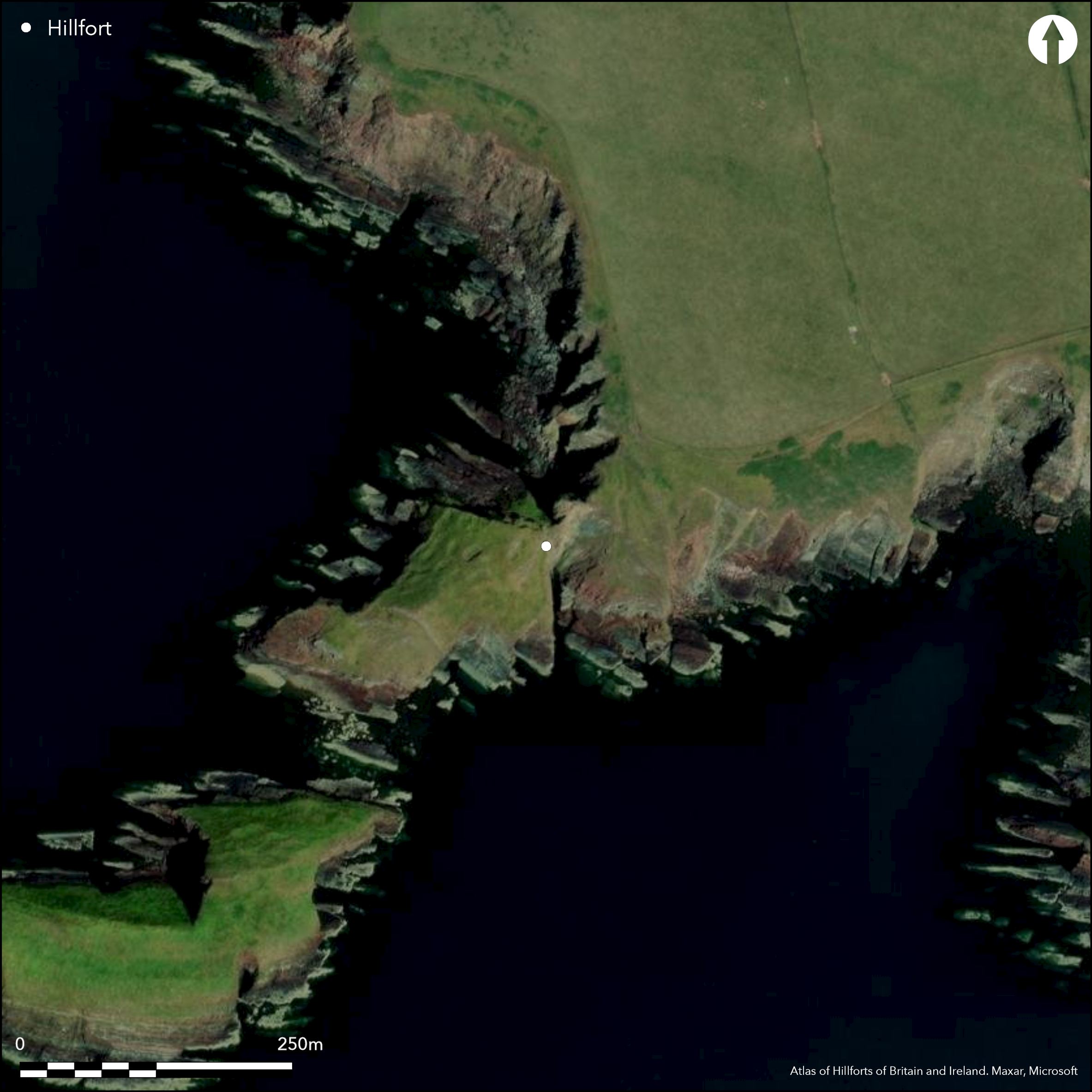
Fairly large for the area and complex coastal promontory fort located on SW-facing headland dominating the entrance to Milford Haven opposite Dale Point and St Ann's Head. Sheep Island is c. 60m offshore on SW, which could have been connected to mainland in prehistory and may have been part of the site. High sea cliffs to 30m on N, S and W sides, moderate slope landward to NE. Three areas to site: Firstly, area just inside rampart. Second a knoll divided from first area by deep gully and thirdly Sheep Island itself. Bank and ditch cut off the narrowest neck of the promontory on the NE running 75m from cliff edge to enclose the first area as an irregular area c. 80m N-S by 40m E-W. Bank stands at c. 2.8m above the ditch, although this and the interior much disturbed by military installations. Encloses 0.8ha. Simple gap entrance towards SE end of bank. Affected here by sea erosion. Steep natural gully separates the first area from the second, and possible hint of second line of defence here along gully. Traces of mortared stone wall also and possible medieval castle site. Rectangular hollows in interior reported by Crossley (1963, 176-77) and suggested as hut platforms in RCAHMW Inventory of 1925, but thought possibly military by Ordnance Survey. Aerial photography by RCAHMW in 2002 shows house platforms also on the site against N. side. Third area, Sheep Island, Iron Age and Romano-British pottery found and hut platforms possible. It is possible that hut platforms do exist in the interior, but these have been confused and masked by modern military installations. Coastal grassland and bare rock; tussocky on Sheep Island. On 1st Ed. OS map (1875).
Citizen Science: ✗
Reliability of Data: Confirmed
Reliability of Interpretation: Confirmed
X: -569677 Y: 6741337 (EPSG: 3857)
Longitude: -5.117496069560024 Latitude: 51.67368382400097 (EPSG:4326)
Country: Wales
Current County or Unitary Authority: Pembrokeshire
Historic County: Pembrokeshire
Current Parish/Community/Council/Townland: Angle
Affected by Pembrokeshire Coast Path to NE. Military installations damaged site.
| Extant | ✓ |
| Cropmark | ✗ |
| Likely Destroyed | ✗ |
Coastal grassland and bare rock; tussocky on Sheep Island. Military installations.
| Woodland | ✗ |
| Commercial Forestry Plantation | ✗ |
| Parkland | ✗ |
| Pasture (Grazing) | ✗ |
| Arable | ✗ |
| Scrub/Bracken | ✗ |
| Bare Outcrop | ✗ |
| Heather/Moorland | ✗ |
| Heath | ✗ |
| Built-up | ✓ |
| Coastal Grassland | ✓ |
| Other | ✓ |
Fairly large for the area and complex coastal promontory fort located on SW-facing headland dominating the entrance to Milford Haven opposite Dale Point and St Ann's Head. Sheep Island is c. 60m offshore on SW, which could have been connected to mainland in prehistory and may have been part of the site. High sea cliffs to 30m on N, S and W sides, moderate slope landward to NE.
| Contour Fort | ✗ |
| Partial Contour Fort | ✗ |
| Promontory Fort | ✓ |
| Hillslope Fort | ✗ |
| Level Terrain Fort | ✗ |
| Marsh Fort | ✗ |
| Multiple Enclosure Fort | ✗ |
| Hilltop | ✗ |
| Coastal Promontory | ✓ |
| Inland Promontory | ✗ |
| Valley Bottom | ✗ |
| Knoll/Hillock/Outcrop | ✗ |
| Ridge | ✗ |
| Cliff/Plateau-edge/Scarp | ✗ |
| Hillslope | ✗ |
| Lowland | ✗ |
| Spur | ✗ |
Dominant Topographic Feature: Coastal headland
| North | ✗ |
| Northeast | ✗ |
| East | ✗ |
| Southeast | ✗ |
| South | ✗ |
| Southwest | ✓ |
| West | ✗ |
| Northwest | ✗ |
| Level | ✗ |
Altitude: 31.0m
N/A
Possibly Iron Age and Romano-British pottery found on Sheep Island off the promontory.
Reliability: C - Low
| Pre 1200BC | ✗ |
| 1200BC - 800BC | ✗ |
| 800BC - 400BC | ✗ |
| 400BC - AD50 | ✓ |
| AD50 - AD400 | ✗ |
| AD400 - AD 800 | ✗ |
| Post AD800 | ✗ |
| Unknown | ✗ |
| Pre Hillfort: | None |
| Post Hillfort: | None |
| Artefactual: | Chance finds of Roman-British pottery on Sheep Island. |
| Morphology/Earthwork/Typology: | Possibly Iron Age. |
Described by George Owen c. 1600. On 1st Ed. OS map (1875). Field Observation OS 1965, 1975. Field Observation DAT 1994, 1996, 1999. Cambria Archaeology defended enclosures survey 2006-2007.
| 1st Identified Written Reference (1600): | Described by George Owen. |
| 1st Identified Map Depiction (1875): | OS map. |
| Other (None): | Field observation OS. |
| Other (None): | Field observation DAT. |
| Other (None): | Cambria Archaeology defended enclosures survey. |
Rectangular hollows thought possibly later military by Ordnance Survey and not hut circles as RCAHMW Inventory of 1925 suggests, but this is uncertain and modern aerial photography by RCAHMW in 2002 shows house platforms on site against N side. It is likely that more hut platforms do exist in the interior, but these have been confused and masked by modern military installations. Hut platforms possible on Sheep Island.Chance finds of Roman-British pottery on Sheep Island.
Stream 0.35km outside fort.
| None | ✓ |
| Spring | ✗ |
| Stream | ✗ |
| Pool | ✗ |
| Flush | ✗ |
| Well | ✗ |
| Other | ✗ |
Rectangular hollows thought possibly later military by Ordnance Survey and not hut circles as RCAHMW Inventory of 1925 suggests, but this is uncertain and modern aerial photography by RCAHMW in 2002 shows house platforms on site against N side. It is likely that more hut platforms do exist in the interior, but these have been confused and masked by modern military installations. Hut platforms possible on Sheep Island.
| No Known Features | ✗ |
| Round Stone Structures | ✗ |
| Rectangular Stone Structures | ✗ |
| Curvilinear Platforms | ✓ |
| Other Roundhouse Evidence | ✗ |
| Pits | ✗ |
| Quarry Hollows | ✗ |
| Other | ✗ |
None
| No Known Excavation | ✓ |
| Pits | ✗ |
| Postholes | ✗ |
| Roundhouses | ✗ |
| Rectangular Structures | ✗ |
| Roads/Tracks | ✗ |
| Quarry Hollows | ✗ |
| Other | ✗ |
| Nothing Found | ✗ |
None
| No Known Geophysics | ✓ |
| Pits | ✗ |
| Roundhouses | ✗ |
| Rectangular Structures | ✗ |
| Roads/Tracks | ✗ |
| Quarry Hollows | ✗ |
| Other | ✗ |
| Nothing Found | ✗ |
Chance finds of Roman-British pottery on Sheep Island.
| No Known Finds | ✗ |
| Pottery | ✓ |
| Metal | ✗ |
| Metalworking | ✗ |
| Human Bones | ✗ |
| Animal Bones | ✗ |
| Lithics | ✗ |
| Environmental | ✗ |
| Other | ✗ |
Aerial photography (RCAHMW 2002) shows house platforms against N side.
| APs Not Checked | ✗ |
| None | ✗ |
| Roundhouses | ✗ |
| Rectangular Structures | ✗ |
| Pits | ✗ |
| Postholes | ✗ |
| Roads/Tracks | ✗ |
| Other | ✓ |
Simple gap entrance towards SE end of bank.
| 1: | None |
| 2: | None |
Guard Chambers: ✗
Chevaux de Frise: ✗
| 1. Simple Gap (South east): | None |
Bank and ditch cut off the narrowest neck of the promontory on the NE running 75m from cliff edge to enclose the first area as an irregular area c. 80m N-S by 40m E-W. Bank stands at c. 2.8m above the ditch. Possible second line of defence along gully where traces of mortared stone wall.
| Area 1: | 0.8ha. |
| Total: | 0.8ha. |
Total Footprint Area: Noneha.
None
| ✗ | None |
| ✗ | None |
| NE Quadrant: | 1 |
| SE Quadrant: | 0 |
| SW Quadrant: | 0 |
| NW Quadrant: | 0 |
| Total: | 1 |
| Partial Univallate | ✓ |
| Univallate | ✗ |
| Partial Bivallate | ✗ |
| Bivallate | ✗ |
| Partial Multivallate | ✗ |
| Multivallate | ✗ |
| Unknown | ✗ |
| Partial Univallate | ✗ |
| Univallate | ✗ |
| Partial Bivallate | ✗ |
| Bivallate | ✗ |
| Partial Multivallate | ✗ |
| Multivallate | ✗ |
Probably stone-walled site. Traces of mortared stone wall along gully possibly medieval?
| None | ✗ |
| Earthen Bank | ✗ |
| Stone Wall | ✓ |
| Rubble | ✗ |
| Wall-walk | ✗ |
| Evidence of Timber | ✗ |
| Vitrification | ✗ |
| Other Burning | ✗ |
| Palisade | ✗ |
| Counter Scarp Bank | ✗ |
| Berm | ✗ |
| Unfinished | ✗ |
| Other | ✗ |
None
| None | ✗ |
| Earthen Bank | ✗ |
| Stone Wall | ✗ |
| Murus Duplex | ✗ |
| Timber-framed | ✗ |
| Timber-laced | ✗ |
| Vitrification | ✗ |
| Other Burning | ✗ |
| Palisade | ✗ |
| Counter Scarp Bank | ✗ |
| Berm | ✗ |
| Unfinished | ✗ |
| No Known Excavation | ✓ |
| Other | ✗ |
| ✗ | None |
| ✓ | None |
Number of Ditches: 1
| ✗ | None |
Crossley, D.W. 1963. List of Hill-Forts and other earthworks in Pembrokeshire, Bull Board Celtic Stud, 20, 176-77.
Murphy, K., Ramsey, R., Poucher, P. and Page, M. 2007. A Survey of Defended Enclosures in Pembrokeshire, 2006-2007: Gazetteer of Ordnance Survey Grid Squares SM70 and SM80, Cambria Archaeology Report No. 2007/01, Project Record No. 54269, Llandeilo: Cambria Archaeology.
RCAMWM 1925: Pembrokeshire Inventory No. 214; RCAMWM 1925. An inventory of the ancient monuments in Wales and Monmouthshire, VII, County of Pembroke, London: HMSO, No. 19.
Atlas of Hillforts:
Wikidata:
This work is licensed under CC BY-SA 4.0

 and should be cited as:
Lock, Gary and Ralston, Ian. 2024. Atlas of Hillforts of Britain and Ireland. Available at: https://hillforts.arch.ox.ac.uk
Document Version 1.1