LiDAR 1m DTM Hillshade

Satellite Imagery
LiDAR 1m DTM Hillshade
Satellite Imagery
Scroll left/right to view further images.
HER: Dyfed 3573 (None)
NMR: SN 01 NE (304410)
SM: PE102(PEM)
NGR: SN 0730 1820
X: 207300 Y: 218200 (OSGB36)
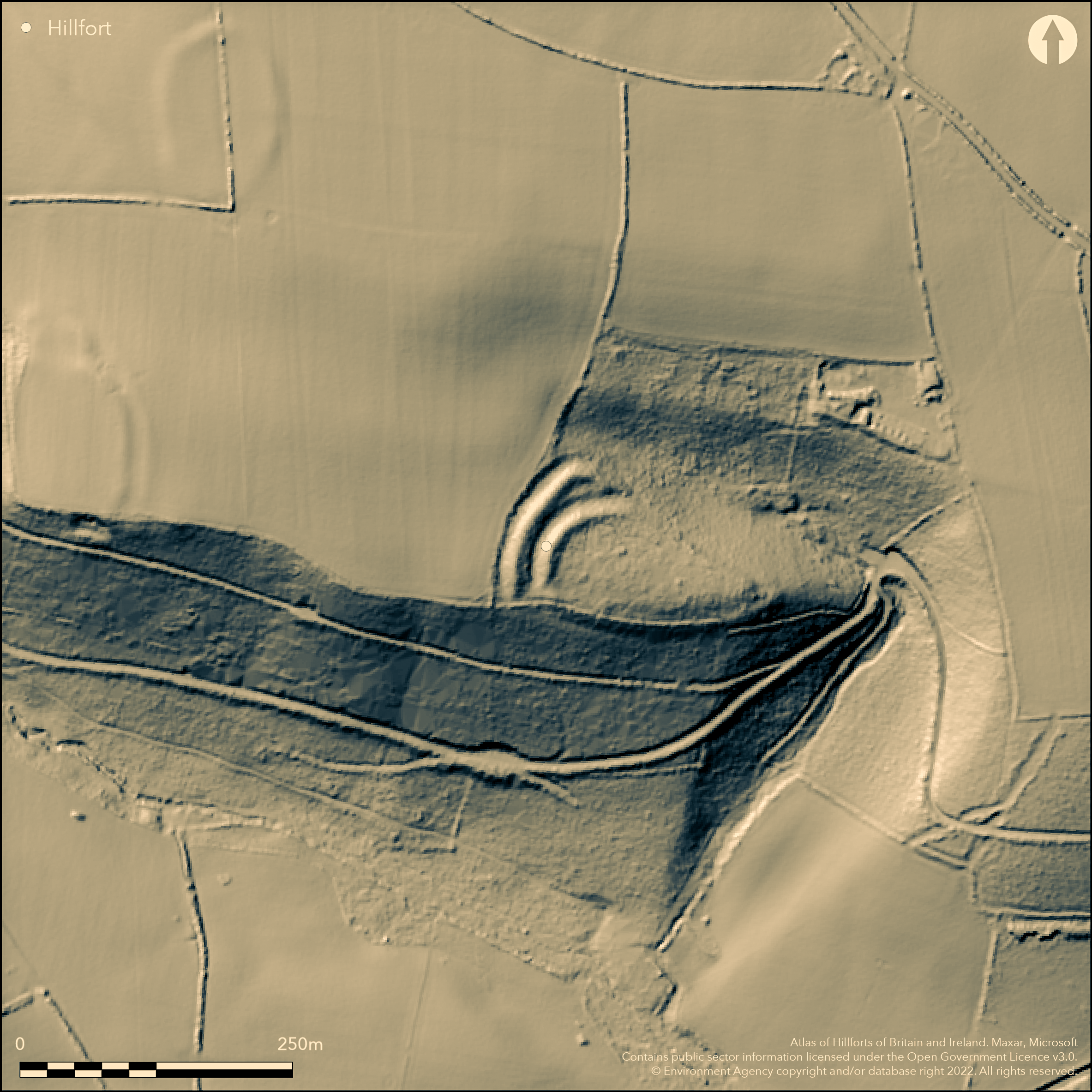
Inland promontory fort located on SE-facing promontory above Drim Wood and wooded stream to E and confluence to S, flowing into Cleddau Ddu to SW. Steep slopes to N, E and S, rising moderately to NW. Triangular in form, interior measuring c. 110m E-W by 50m, with area c. 0.55ha. Two strong curving earth banks and ditches with counterscarp on W side running from NE-SW cut off the promontory on the NW side, now overlain by hedge-bank. Banks c. 12m wide and rise to over 4m above the ditches which are c. 6m wide. Inner bank continues around the whole of the promontory in much reduced form. Entrance on S limit of banks where gap before steep slopes. Section excavated through defences in early 1980's by G. Williams and H. Mytum (1998) showed that ditches almost 3m deep and that banks had front and rear timber palisades. C14 dates suggest short-lived occupation in 4th and 3rd centuries BC. Under coniferous forestry and affected by forestry operations. On 1st Ed. OS map (1889-90).
Citizen Science: ✗
Reliability of Data: Confirmed
Reliability of Interpretation: Confirmed
X: -534110 Y: 6769275 (EPSG: 3857)
Longitude: -4.797987656913313 Latitude: 51.829053364772335 (EPSG:4326)
Country: Wales
Current County or Unitary Authority: Pembrokeshire
Historic County: Pembrokeshire
Current Parish/Community/Council/Townland: Llawhaden
Affected by forest operations.
| Extant | ✓ |
| Cropmark | ✗ |
| Likely Destroyed | ✗ |
Coniferous forestry.
| Woodland | ✗ |
| Commercial Forestry Plantation | ✓ |
| Parkland | ✗ |
| Pasture (Grazing) | ✗ |
| Arable | ✗ |
| Scrub/Bracken | ✗ |
| Bare Outcrop | ✗ |
| Heather/Moorland | ✗ |
| Heath | ✗ |
| Built-up | ✗ |
| Coastal Grassland | ✗ |
| Other | ✗ |
Inland promontory fort located on SE-facing promontory above Drim Wood and wooded stream to E and confluence to S, flowing into Cleddau Ddu to SW. Steep slopes to N, E and S, rising moderately to NW.
| Contour Fort | ✗ |
| Partial Contour Fort | ✗ |
| Promontory Fort | ✓ |
| Hillslope Fort | ✗ |
| Level Terrain Fort | ✗ |
| Marsh Fort | ✗ |
| Multiple Enclosure Fort | ✗ |
| Hilltop | ✗ |
| Coastal Promontory | ✗ |
| Inland Promontory | ✓ |
| Valley Bottom | ✗ |
| Knoll/Hillock/Outcrop | ✗ |
| Ridge | ✗ |
| Cliff/Plateau-edge/Scarp | ✗ |
| Hillslope | ✗ |
| Lowland | ✗ |
| Spur | ✓ |
Dominant Topographic Feature: Spur promontory
| North | ✗ |
| Northeast | ✗ |
| East | ✗ |
| Southeast | ✓ |
| South | ✗ |
| Southwest | ✗ |
| West | ✗ |
| Northwest | ✗ |
| Level | ✗ |
Altitude: 95.0m
N/A
C14 dates suggest short-lived occupation in the 4th and 3rd centuries BC.
Reliability: B - Medium
| Pre 1200BC | ✗ |
| 1200BC - 800BC | ✗ |
| 800BC - 400BC | ✗ |
| 400BC - AD50 | ✓ |
| AD50 - AD400 | ✗ |
| AD400 - AD 800 | ✗ |
| Post AD800 | ✗ |
| Unknown | ✗ |
| Pre Hillfort: | None |
| Post Hillfort: | None |
| C14: | Dates of 4th and 3rd centuries BC. |
On 1st Ed. OS map (1889-90). Field Observation OS 1966. Field observation AMB 1981. Section excavated through defences in early 1980's by G. Williams and H. Mytum. Trial excavation DAT 1984. Field observation CADW 2000. Cambria Archaeology defended enclosures survey 2006-2007.
| Other (1966): | Field Observation OS. |
| Other (1981): | Field observation AMB. |
| Excavation (1984): | Trial excavation DAT. |
| Other (2000): | Field observation CADW. |
| 1st Identified Map Depiction (None): | OS map. |
| Other (None): | Cambria Archaeology defended enclosures survey. |
| Excavation (None): | Section excavated through defences in early 1980's by G. Williams and H. Mytum. |
None
None
| None | ✓ |
| Spring | ✗ |
| Stream | ✗ |
| Pool | ✗ |
| Flush | ✗ |
| Well | ✗ |
| Other | ✗ |
None
| No Known Features | ✓ |
| Round Stone Structures | ✗ |
| Rectangular Stone Structures | ✗ |
| Curvilinear Platforms | ✗ |
| Other Roundhouse Evidence | ✗ |
| Pits | ✗ |
| Quarry Hollows | ✗ |
| Other | ✗ |
None
| No Known Excavation | ✓ |
| Pits | ✗ |
| Postholes | ✗ |
| Roundhouses | ✗ |
| Rectangular Structures | ✗ |
| Roads/Tracks | ✗ |
| Quarry Hollows | ✗ |
| Other | ✗ |
| Nothing Found | ✗ |
None
| No Known Geophysics | ✓ |
| Pits | ✗ |
| Roundhouses | ✗ |
| Rectangular Structures | ✗ |
| Roads/Tracks | ✗ |
| Quarry Hollows | ✗ |
| Other | ✗ |
| Nothing Found | ✗ |
None
| No Known Finds | ✓ |
| Pottery | ✗ |
| Metal | ✗ |
| Metalworking | ✗ |
| Human Bones | ✗ |
| Animal Bones | ✗ |
| Lithics | ✗ |
| Environmental | ✗ |
| Other | ✗ |
None
| APs Not Checked | ✓ |
| None | ✗ |
| Roundhouses | ✗ |
| Rectangular Structures | ✗ |
| Pits | ✗ |
| Postholes | ✗ |
| Roads/Tracks | ✗ |
| Other | ✗ |
Entrance on S limit of banks where gap before steep slopes.
| 1: | None |
| 2: | None |
Guard Chambers: ✗
Chevaux de Frise: ✗
| 1. Simple Gap (South west): | None |
Section excavated through defences in early 1980s by G. Williams and H. Mytum showed that ditches almost 3m deep and that banks had front and rear timber palisades.
| Area 1: | 0.55ha. |
| Total: | 0.55ha. |
Total Footprint Area: Noneha.
None
| ✗ | None |
| ✓ | None |
| NE Quadrant: | 1 |
| SE Quadrant: | 1 |
| SW Quadrant: | 2 |
| NW Quadrant: | 2 |
| Total: | 2 |
| Partial Univallate | ✓ |
| Univallate | ✗ |
| Partial Bivallate | ✓ |
| Bivallate | ✗ |
| Partial Multivallate | ✗ |
| Multivallate | ✗ |
| Unknown | ✗ |
| Partial Univallate | ✗ |
| Univallate | ✗ |
| Partial Bivallate | ✗ |
| Bivallate | ✗ |
| Partial Multivallate | ✗ |
| Multivallate | ✗ |
None
| None | ✗ |
| Earthen Bank | ✓ |
| Stone Wall | ✗ |
| Rubble | ✗ |
| Wall-walk | ✗ |
| Evidence of Timber | ✗ |
| Vitrification | ✗ |
| Other Burning | ✗ |
| Palisade | ✗ |
| Counter Scarp Bank | ✓ |
| Berm | ✗ |
| Unfinished | ✗ |
| Other | ✗ |
Earth banks wth front and rear timber palisades.
| None | ✗ |
| Earthen Bank | ✓ |
| Stone Wall | ✗ |
| Murus Duplex | ✗ |
| Timber-framed | ✗ |
| Timber-laced | ✗ |
| Vitrification | ✗ |
| Other Burning | ✗ |
| Palisade | ✓ |
| Counter Scarp Bank | ✗ |
| Berm | ✗ |
| Unfinished | ✗ |
| No Known Excavation | ✗ |
| Other | ✗ |
| ✗ | None |
| ✓ | Section excavated through defences in early 1980s by G. Williams and H. Mytum showed that ditches almost 3m deep. |
Number of Ditches: 2
| ✗ | None |
Murphy, K., Ramsey, R., Poucher, P. and Page, M. 2007. A Survey of Defended Enclosures in Pembrokeshire, 2006-2007: Gazetteer of Ordnance Survey Grid Squares SN01, Cambria Archaeology Report No. 2007/01, Project Record No. 54269, Llandeilo: Cambria Archaeology.
Williams, G.H. and Mytum, H. 1998. Llawhaden, Dyfed. Excavations on a group of small defended enclosures, 198-84, BAR British Series 275, Oxford: Archaeopress.
Atlas of Hillforts:
Wikidata:
This work is licensed under CC BY-SA 4.0![]()
![]()
![]() and should be cited as:
and should be cited as:
Lock, Gary and Ralston, Ian. 2024. Atlas of Hillforts of Britain and Ireland. Available at: https://hillforts.arch.ox.ac.uk
Document Version 1.1