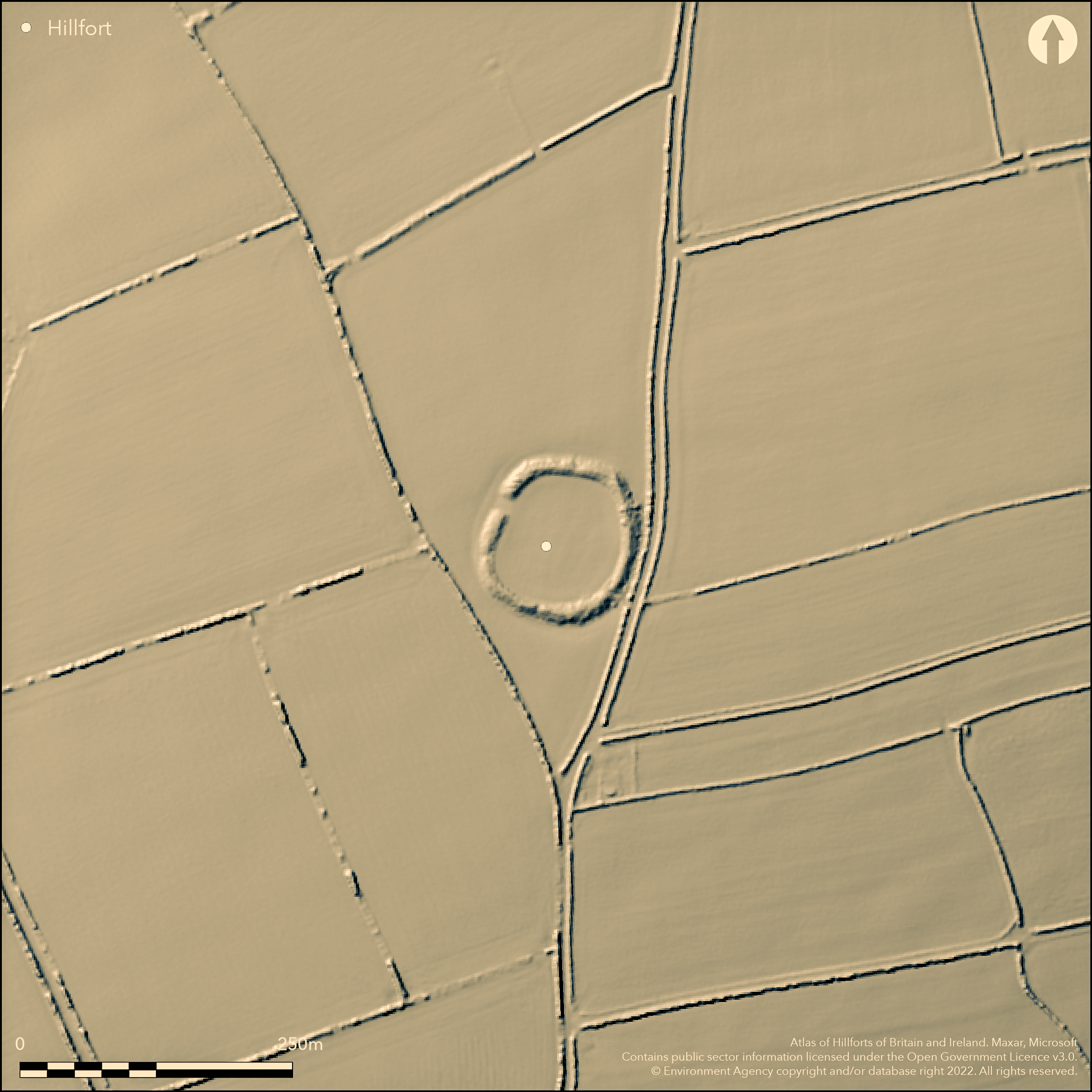
LiDAR 1m DTM Hillshade
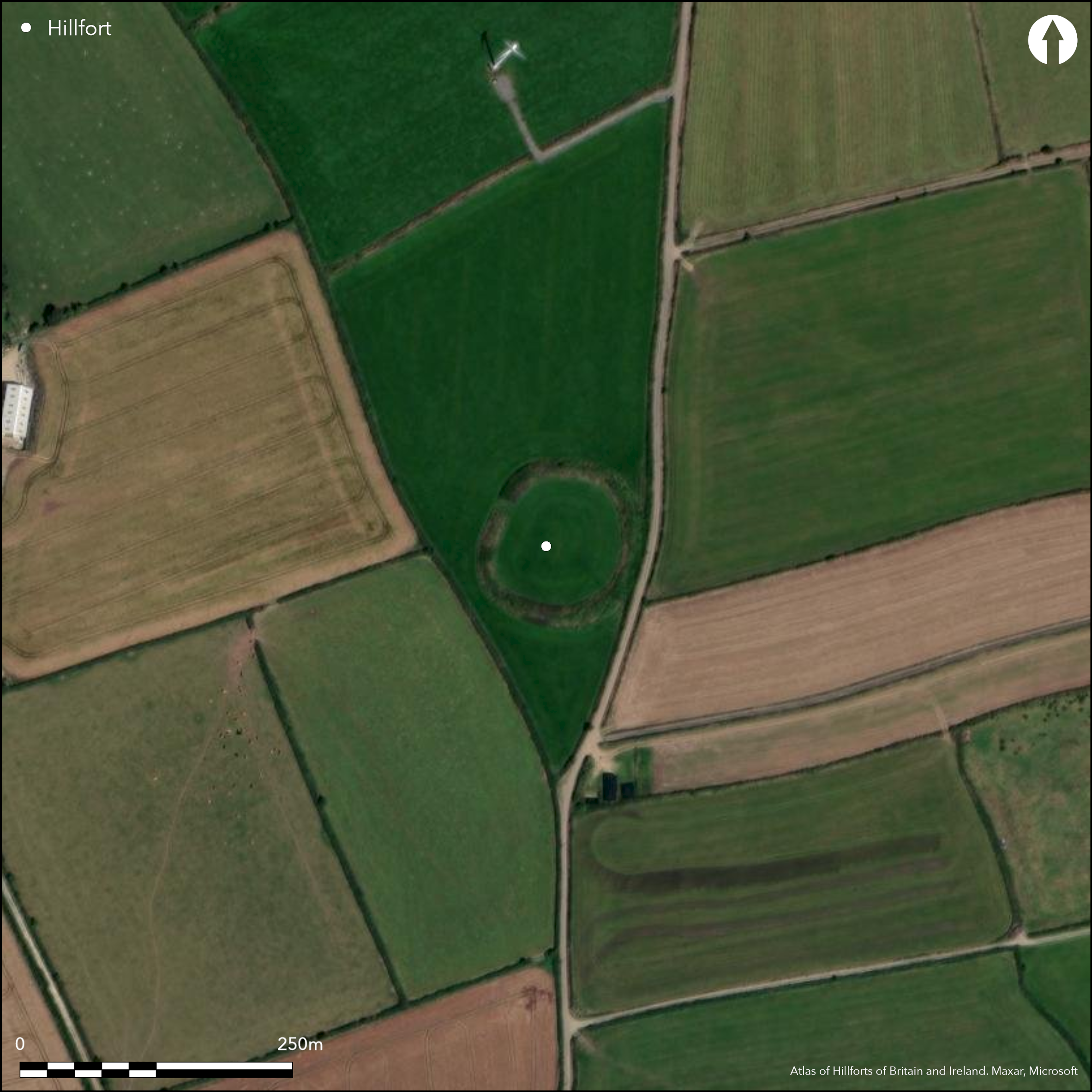
Satellite Imagery
LiDAR 1m DTM Hillshade
Satellite Imagery
Scroll left/right to view further images.
HER: Dyfed 2576 (None)
NMR: SM 93 SW (305195)
SM: PE081(PEM)
NGR: SM 9208 3371
X: 192080 Y: 233710 (OSGB36)
Partial contour hillfort sited near to the top of a prominent hill between two streams and facing W down a valley to Aber Bach and possible landing. Moderate surrounding slopes to N and S, moderate to strong to E and W. Sub-circular in shape measures c. 75m by 84m, with slightly concave internal area of 0.45ha. Single bank to 2m above an intermittent ditch, best on SE near a hedge-bank, but ploughed out on N quadrants. Wide gap of 7m on NW side site of original entrance. Improved pasture interior with scrub on banks which show up well, but ditch ploughed out on N quadrants. On 1st Ed. OS map (1889). Minimal investigations, undated.
Citizen Science: ✗
Reliability of Data: Confirmed
Reliability of Interpretation: Confirmed
X: -559704 Y: 6793411 (EPSG: 3857)
Longitude: -5.027903484928786 Latitude: 51.96285191887822 (EPSG:4326)
Country: Wales
Current County or Unitary Authority: Pembrokeshire
Historic County: Pembrokeshire
Current Parish/Community/Council/Townland: Scleddau
Bank show up well, but ditch ploughed out on N quadrants.
| Extant | ✓ |
| Cropmark | ✗ |
| Likely Destroyed | ✗ |
Improved pasture interior with scrub on banks.
| Woodland | ✗ |
| Commercial Forestry Plantation | ✗ |
| Parkland | ✗ |
| Pasture (Grazing) | ✓ |
| Arable | ✗ |
| Scrub/Bracken | ✓ |
| Bare Outcrop | ✗ |
| Heather/Moorland | ✗ |
| Heath | ✗ |
| Built-up | ✗ |
| Coastal Grassland | ✗ |
| Other | ✗ |
Hillslope fort sited near to the top of a prominent hill between two streams and facing west down a valley to Aber Bach and possible landing.
| Contour Fort | ✗ |
| Partial Contour Fort | ✓ |
| Promontory Fort | ✗ |
| Hillslope Fort | ✗ |
| Level Terrain Fort | ✗ |
| Marsh Fort | ✗ |
| Multiple Enclosure Fort | ✗ |
| Hilltop | ✓ |
| Coastal Promontory | ✗ |
| Inland Promontory | ✗ |
| Valley Bottom | ✗ |
| Knoll/Hillock/Outcrop | ✗ |
| Ridge | ✗ |
| Cliff/Plateau-edge/Scarp | ✗ |
| Hillslope | ✗ |
| Lowland | ✗ |
| Spur | ✗ |
Dominant Topographic Feature: Hill top
| North | ✗ |
| Northeast | ✗ |
| East | ✗ |
| Southeast | ✗ |
| South | ✗ |
| Southwest | ✗ |
| West | ✓ |
| Northwest | ✗ |
| Level | ✗ |
Altitude: 130.0m
N/A
Reliability: D - None
| Pre 1200BC | ✗ |
| 1200BC - 800BC | ✗ |
| 800BC - 400BC | ✗ |
| 400BC - AD50 | ✗ |
| AD50 - AD400 | ✗ |
| AD400 - AD 800 | ✗ |
| Post AD800 | ✗ |
| Unknown | ✓ |
| Pre Hillfort: | None |
| Post Hillfort: | None |
On 1st Ed. OS map (1889). Field Observation OS 1966. Field Observation AMB 1981. Field Observation CADW 1985, 1990, 1998. Cambria Archaeology defended enclosures survey 2006-2007.
| 1st Identified Map Depiction (1889): | OS map. |
| Other (1966): | Field observation OS. |
| Other (1981): | Field observation AMB. |
| Other (None): | Field observation CADW., |
| Other (None): | Cambria Archaeology defended enclosures survey. |
None
Stream 0.6km outside fort.
| None | ✓ |
| Spring | ✗ |
| Stream | ✗ |
| Pool | ✗ |
| Flush | ✗ |
| Well | ✗ |
| Other | ✗ |
None
| No Known Features | ✓ |
| Round Stone Structures | ✗ |
| Rectangular Stone Structures | ✗ |
| Curvilinear Platforms | ✗ |
| Other Roundhouse Evidence | ✗ |
| Pits | ✗ |
| Quarry Hollows | ✗ |
| Other | ✗ |
None
| No Known Excavation | ✓ |
| Pits | ✗ |
| Postholes | ✗ |
| Roundhouses | ✗ |
| Rectangular Structures | ✗ |
| Roads/Tracks | ✗ |
| Quarry Hollows | ✗ |
| Other | ✗ |
| Nothing Found | ✗ |
None
| No Known Geophysics | ✓ |
| Pits | ✗ |
| Roundhouses | ✗ |
| Rectangular Structures | ✗ |
| Roads/Tracks | ✗ |
| Quarry Hollows | ✗ |
| Other | ✗ |
| Nothing Found | ✗ |
None
| No Known Finds | ✓ |
| Pottery | ✗ |
| Metal | ✗ |
| Metalworking | ✗ |
| Human Bones | ✗ |
| Animal Bones | ✗ |
| Lithics | ✗ |
| Environmental | ✗ |
| Other | ✗ |
None
| APs Not Checked | ✓ |
| None | ✗ |
| Roundhouses | ✗ |
| Rectangular Structures | ✗ |
| Pits | ✗ |
| Postholes | ✗ |
| Roads/Tracks | ✗ |
| Other | ✗ |
Wide gap of 7m on NW side site of original entrance. Possible gap on S.
| 2: | Possible gap on S. |
| 2: | None |
Guard Chambers: ✗
Chevaux de Frise: ✗
| 1. Simple Gap (North west): | Wide gap. |
Single bank to 2m above an intermittent ditch, best on SE near a hedge-bank, but ploughed out on N quadrants.
| Area 1: | 0.45ha. |
| Total: | 0.45ha. |
Total Footprint Area: Noneha.
None
| ✗ | None |
| ✓ | None |
| NE Quadrant: | 1 |
| SE Quadrant: | 1 |
| SW Quadrant: | 1 |
| NW Quadrant: | 1 |
| Total: | 1 |
| Partial Univallate | ✗ |
| Univallate | ✓ |
| Partial Bivallate | ✗ |
| Bivallate | ✗ |
| Partial Multivallate | ✗ |
| Multivallate | ✗ |
| Unknown | ✗ |
| Partial Univallate | ✗ |
| Univallate | ✗ |
| Partial Bivallate | ✗ |
| Bivallate | ✗ |
| Partial Multivallate | ✗ |
| Multivallate | ✗ |
None
| None | ✗ |
| Earthen Bank | ✓ |
| Stone Wall | ✗ |
| Rubble | ✗ |
| Wall-walk | ✗ |
| Evidence of Timber | ✗ |
| Vitrification | ✗ |
| Other Burning | ✗ |
| Palisade | ✗ |
| Counter Scarp Bank | ✗ |
| Berm | ✗ |
| Unfinished | ✗ |
| Other | ✗ |
None
| None | ✗ |
| Earthen Bank | ✗ |
| Stone Wall | ✗ |
| Murus Duplex | ✗ |
| Timber-framed | ✗ |
| Timber-laced | ✗ |
| Vitrification | ✗ |
| Other Burning | ✗ |
| Palisade | ✗ |
| Counter Scarp Bank | ✗ |
| Berm | ✗ |
| Unfinished | ✗ |
| No Known Excavation | ✓ |
| Other | ✗ |
| ✗ | None |
| ✓ | Ditch best on SE near a hedge-bank, but ploughed out on N quadrants. |
Number of Ditches: 1
| ✗ | None |
Crossley, D.W. 1963. List of Hill-Forts and other earthworks in Pembrokeshire, Bull Board Celtic Stud, 20, 194.
Murphy, K., Ramsey, R., Poucher, P. and Page, M. 2007. A Survey of Defended Enclosures in Pembrokeshire, 2006-2007: Gazetteer of Ordnance Survey Grid Squares SM73, SM83 and SM93, Cambria Archaeology Report No. 2007/01, Project Record No. 54269, Llandeilo: Cambria Archaeology.
Atlas of Hillforts:
Wikidata:
This work is licensed under CC BY-SA 4.0![]()
![]()
![]() and should be cited as:
and should be cited as:
Lock, Gary and Ralston, Ian. 2024. Atlas of Hillforts of Britain and Ireland. Available at: https://hillforts.arch.ox.ac.uk
Document Version 1.1