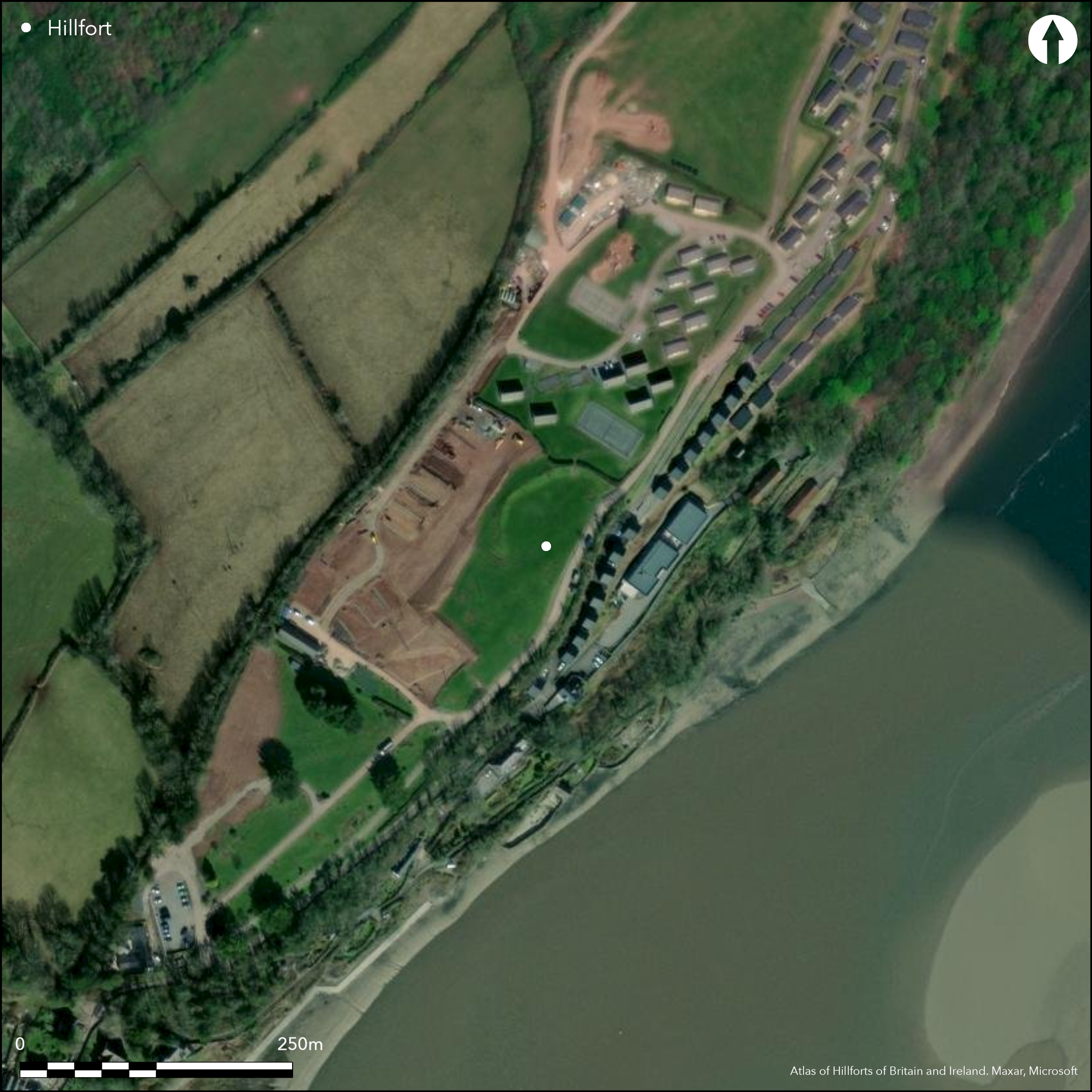
Satellite Imagery
Satellite Imagery
HER: Dyfed 2158 (None)
NMR: SN 31 SW 7 (304152)
SM: CM232(CAM)
NGR: SN 3063 1117
X: 230630 Y: 211170 (OSGB36)
Sited on a gentle SW-facing slope above the estuary of the Afon Taf where it begins to narrow. Moderate to strong surrounding slopes to N and W, steep to S and E. D-shaped, measuring c. 70m NE-SW by 50m-60m, with internal area c. 0.5ha. Because of development, including road on S, and change in coastline through erosion since the Iron Age, the site could have lost all of its S side. Now only defined by an arcing crescent-shaped, but incomplete, bank from SW through to NE quadrants c. 1.5m high and traces of ditch, with natural slopes on the steep SE above the Taf estuary. On E bank meets the steep slope, but on SW stops c. 40m short. Geophysical survey of 1991 showed that ditch stopped short also, but with little of interest in interior. It is possible that the site was unfinished. No entrance visible. Site was trenched by Falkener in 1907, producing no dateable finds. Later chance finds of a bronze button and possible later Iron Age or Romano-British pottery. Roman coin found nearby. No details of possible late excavation by Weinholt. Possibly used as location to mount guns during siege of Laugharne Castle during Civil War. Setting and site much affected by development and now lies within open space of holiday camp.
Citizen Science: ✗
Reliability of Data: Confirmed
Reliability of Interpretation: Confirmed
X: -496077 Y: 6759269 (EPSG: 3857)
Longitude: -4.456333142245889 Latitude: 51.77346779922322 (EPSG:4326)
Country: Wales
Current County or Unitary Authority: Carmarthenshire
Historic County: Carmarthenshire
Current Parish/Community/Council/Townland: Laugharne Township
Setting and site much affected by development. Because of development, including road on S, and change in coastline through erosion since the Iron Age, the site could have lost all of its S side.
| Extant | ✓ |
| Cropmark | ✗ |
| Likely Destroyed | ✓ |
Site lies within open space of holiday camp.
| Woodland | ✗ |
| Commercial Forestry Plantation | ✗ |
| Parkland | ✓ |
| Pasture (Grazing) | ✗ |
| Arable | ✗ |
| Scrub/Bracken | ✗ |
| Bare Outcrop | ✗ |
| Heather/Moorland | ✗ |
| Heath | ✗ |
| Built-up | ✓ |
| Coastal Grassland | ✗ |
| Other | ✓ |
Sited on a gentle SW-facing slope above the estuary of the Afon Taf where it begins to narrow. Moderate to strong surrounding slopes to N and W, steep to S and E.
| Contour Fort | ✗ |
| Partial Contour Fort | ✗ |
| Promontory Fort | ✗ |
| Hillslope Fort | ✓ |
| Level Terrain Fort | ✗ |
| Marsh Fort | ✗ |
| Multiple Enclosure Fort | ✗ |
| Hilltop | ✗ |
| Coastal Promontory | ✗ |
| Inland Promontory | ✗ |
| Valley Bottom | ✗ |
| Knoll/Hillock/Outcrop | ✗ |
| Ridge | ✗ |
| Cliff/Plateau-edge/Scarp | ✓ |
| Hillslope | ✓ |
| Lowland | ✗ |
| Spur | ✗ |
Dominant Topographic Feature: Scarp edge.
| North | ✗ |
| Northeast | ✗ |
| East | ✗ |
| Southeast | ✗ |
| South | ✗ |
| Southwest | ✓ |
| West | ✗ |
| Northwest | ✗ |
| Level | ✗ |
Altitude: 61.0m
N/A
Chance finds of bronze button and possible later Iron Age or Romano-British pottery. Roman coin found nearby.
Reliability: C - Low
| Pre 1200BC | ✗ |
| 1200BC - 800BC | ✗ |
| 800BC - 400BC | ✗ |
| 400BC - AD50 | ✓ |
| AD50 - AD400 | ✓ |
| AD400 - AD 800 | ✗ |
| Post AD800 | ✗ |
| Unknown | ✗ |
| Pre Hillfort: | None |
| Post Hillfort: | None |
| Artefactual: | Chance finds. |
Part Excavation by E. Falkener 1907 - no details. Part Excavation by Weinholt - no date. Field Investigation RCAHM 1912. Field Observation OS 1967. Field Observation DAT 1985, 1994, 1996. Field Observation CADW 1994, 2003. Geophysical survey 1991 - no details. Dyfed Archaeological Tryst defended enclosures survey 2007-2008.
| Excavation (1907): | E. Falkener - no details. |
| Other (1912): | Field observation RCAHM. |
| Other (1967): | Field observation OS. |
| Geophysical Survey (1991): | No details. |
| Other (None): | Field observation DAT. |
| Other (None): | Field observation CADW. |
| Other (None): | Dyfed Archaeological Tryst defended enclosures survey |
| Excavation (None): | Weinholt |
Chance finds of a bronze button and possible later Iron Age or Romano-British pottery. Roman coin found nearby.
Afon Taf 0.1km outside fort.
| None | ✓ |
| Spring | ✗ |
| Stream | ✗ |
| Pool | ✗ |
| Flush | ✗ |
| Well | ✗ |
| Other | ✗ |
None
| No Known Features | ✓ |
| Round Stone Structures | ✗ |
| Rectangular Stone Structures | ✗ |
| Curvilinear Platforms | ✗ |
| Other Roundhouse Evidence | ✗ |
| Pits | ✗ |
| Quarry Hollows | ✗ |
| Other | ✗ |
None
| No Known Excavation | ✗ |
| Pits | ✗ |
| Postholes | ✗ |
| Roundhouses | ✗ |
| Rectangular Structures | ✗ |
| Roads/Tracks | ✗ |
| Quarry Hollows | ✗ |
| Other | ✗ |
| Nothing Found | ✓ |
Nothing of interest found.
| No Known Geophysics | ✗ |
| Pits | ✗ |
| Roundhouses | ✗ |
| Rectangular Structures | ✗ |
| Roads/Tracks | ✗ |
| Quarry Hollows | ✗ |
| Other | ✗ |
| Nothing Found | ✓ |
Chance finds of a bronze button and possible later Iron Age or Romano-British pottery. Roman coin found nearby.
| No Known Finds | ✗ |
| Pottery | ✓ |
| Metal | ✓ |
| Metalworking | ✗ |
| Human Bones | ✗ |
| Animal Bones | ✗ |
| Lithics | ✗ |
| Environmental | ✗ |
| Other | ✗ |
None
| APs Not Checked | ✓ |
| None | ✗ |
| Roundhouses | ✗ |
| Rectangular Structures | ✗ |
| Pits | ✗ |
| Postholes | ✗ |
| Roads/Tracks | ✗ |
| Other | ✗ |
None visible.
| 0: | None |
| 2: | None |
Guard Chambers: ✗
Chevaux de Frise: ✗
Defined by an arcing crescent-shaped, but incomplete, bank from SW through to NE quadrants c. 1.5m high and traces of ditch, with natural defence on the steep SE above the Taf estuary. On E bank meets the steep slope, but on SW stops c. 40m short. Geophysical
| Area 1: | 0.5ha. |
| Total: | 0.5ha. |
Total Footprint Area: Noneha.
None
| ✗ | None |
| ✗ | None |
| NE Quadrant: | 1 |
| SE Quadrant: | 0 |
| SW Quadrant: | 1 |
| NW Quadrant: | 1 |
| Total: | 1 |
| Partial Univallate | ✓ |
| Univallate | ✗ |
| Partial Bivallate | ✗ |
| Bivallate | ✗ |
| Partial Multivallate | ✗ |
| Multivallate | ✗ |
| Unknown | ✗ |
| Partial Univallate | ✗ |
| Univallate | ✗ |
| Partial Bivallate | ✗ |
| Bivallate | ✗ |
| Partial Multivallate | ✗ |
| Multivallate | ✗ |
Bank and ditch stops short of steep slope on SW, possibly indicating site unfinished.
| None | ✗ |
| Earthen Bank | ✓ |
| Stone Wall | ✗ |
| Rubble | ✗ |
| Wall-walk | ✗ |
| Evidence of Timber | ✗ |
| Vitrification | ✗ |
| Other Burning | ✗ |
| Palisade | ✗ |
| Counter Scarp Bank | ✗ |
| Berm | ✗ |
| Unfinished | ✓ |
| Other | ✗ |
None
| None | ✗ |
| Earthen Bank | ✗ |
| Stone Wall | ✗ |
| Murus Duplex | ✗ |
| Timber-framed | ✗ |
| Timber-laced | ✗ |
| Vitrification | ✗ |
| Other Burning | ✗ |
| Palisade | ✗ |
| Counter Scarp Bank | ✗ |
| Berm | ✗ |
| Unfinished | ✗ |
| No Known Excavation | ✓ |
| Other | ✗ |
| ✗ | None |
| ✓ | Trace of ditch visible. |
Number of Ditches: 1
| ✗ | None |
Murphy, F., Ramsey, R., Page, M. and Murphy, K. 2008. A Survey of Defended Enclosures in Carmarthenshire, 2007-08: Gazetteer of Ordnance Survey Grid Squares SN31, Dyfed Archaeological Trust Report No. 2007/27, Project Record No. 62767, Llandeilo: Dyfed Archaeological Trust.
Royal Commission on the ancient and historical monuments and constructions in Wales and Monmouthshire 1917. An inventory of the ancient monuments in Wales and Monmouthshire, V, Carmarthen, 175, London: HMSO.
Savory, H.N. 1954. List of hill-forts and other earthworks in Carmarthenshire. Bull Board Celtic Stud, 16, 62.
Atlas of Hillforts:
Wikidata:
This work is licensed under CC BY-SA 4.0

 and should be cited as:
Lock, Gary and Ralston, Ian. 2024. Atlas of Hillforts of Britain and Ireland. Available at: https://hillforts.arch.ox.ac.uk
Document Version 1.1