LiDAR 1m DTM Hillshade
Satellite Imagery
LiDAR 1m DTM Hillshade
Satellite Imagery
Scroll left/right to view further images.
HER: Dyfed 2024 (None)
NMR: SN 68 SE (303595)
SM: CD069
NGR: SN68958480
X: 268950 Y: 284800 (OSGB36)
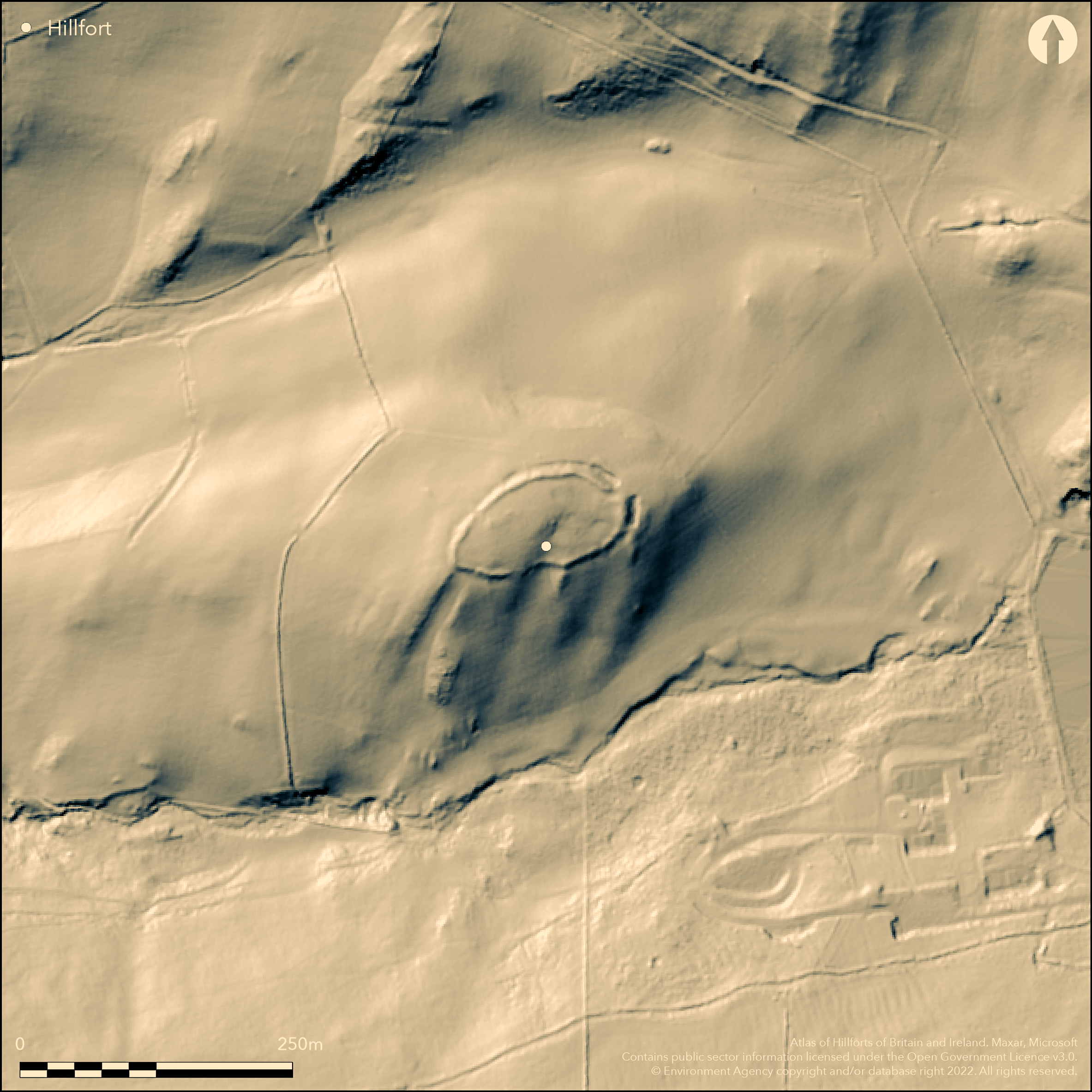
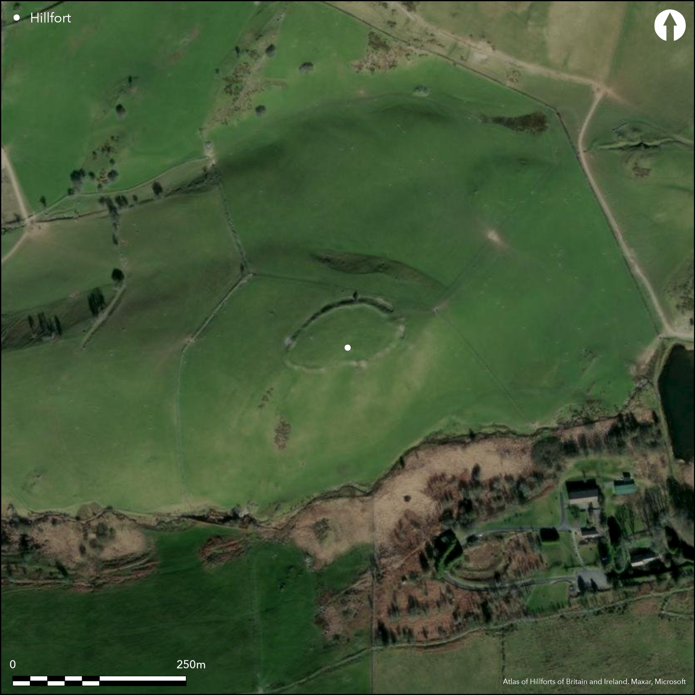
Small, univallate, partial contour hillfort located on spur at the headwaters of the Afon Stewi. N, S, W moderate to strong surrounding slopes, moderate on E where falls to saddle before rising again to Cambrian Mountains. Oval in shape, measuring c. 100m by 50m, with internal area 0.33ha. Defined by strong bank and ditch with slight counterscarp, c. 12m wide overall, with bank to 3m high, especially each side of simple gap entrance on NE, but generally weak. Traces of walling visible on rampart in places. Circuit also not complete, and cannot be traced for 40m on S side. This has resulted in Hogg (1962) suggesting site unfinished. Six house platforms noted by the Ceredigion Archaeological Survey in 1994, one clearly visible on aerial photographs. Under improved pasture. On 1st Ed. OS map 1887. Minimal investigations, unfinished.
Citizen Science: ✗
Reliability of Data: Confirmed
Reliability of Interpretation: Confirmed
X: -437447 Y: 6881059 (EPSG: 3857)
Longitude: -3.929652237741229 Latitude: 52.44537402075968 (EPSG:4326)
Country: Wales
Current County or Unitary Authority: Ceredigion
Historic County: Cardiganshire
Current Parish/Community/Council/Townland: Ceulanamaesmawr
Ploughed in interior. Sheep scrapes on banks. Fair condition with strong bank and ditch.
| Extant | ✓ |
| Cropmark | ✗ |
| Likely Destroyed | ✗ |
Improved pasture.
| Woodland | ✗ |
| Commercial Forestry Plantation | ✗ |
| Parkland | ✗ |
| Pasture (Grazing) | ✓ |
| Arable | ✗ |
| Scrub/Bracken | ✗ |
| Bare Outcrop | ✗ |
| Heather/Moorland | ✗ |
| Heath | ✗ |
| Built-up | ✗ |
| Coastal Grassland | ✗ |
| Other | ✗ |
Small, univallate, partial contour hillfort located on spur at the headwaters of the Afon Stewi. N, S, W Moderate to strong surrounding slopes to N, S and W, moderate on E where falls to saddle before rising again to Cambrian Mountains.
| Contour Fort | ✗ |
| Partial Contour Fort | ✓ |
| Promontory Fort | ✗ |
| Hillslope Fort | ✗ |
| Level Terrain Fort | ✗ |
| Marsh Fort | ✗ |
| Multiple Enclosure Fort | ✗ |
| Hilltop | ✗ |
| Coastal Promontory | ✗ |
| Inland Promontory | ✗ |
| Valley Bottom | ✗ |
| Knoll/Hillock/Outcrop | ✗ |
| Ridge | ✗ |
| Cliff/Plateau-edge/Scarp | ✗ |
| Hillslope | ✗ |
| Lowland | ✗ |
| Spur | ✓ |
Dominant Topographic Feature: Spur
| North | ✗ |
| Northeast | ✗ |
| East | ✗ |
| Southeast | ✗ |
| South | ✗ |
| Southwest | ✗ |
| West | ✓ |
| Northwest | ✗ |
| Level | ✗ |
Altitude: 260.0m
N/A
None
Reliability: D - None
| Pre 1200BC | ✗ |
| 1200BC - 800BC | ✗ |
| 800BC - 400BC | ✗ |
| 400BC - AD50 | ✗ |
| AD50 - AD400 | ✗ |
| AD400 - AD 800 | ✗ |
| Post AD800 | ✗ |
| Unknown | ✓ |
| Pre Hillfort: | None |
| Post Hillfort: | None |
On 1st Ed. OS map 1887. Ceredigion Archaeological Survey 1994. Cambria Archaeology defended enclosures survey 2006.
| 1st Identified Map Depiction (1887): | OS map. |
| Other (1994): | Ceredigion Archaeological Survey 1994. |
| Other (2006): | Cambria Archaeology defended enclosures survey. |
Six house platforms noted by the Ceredigion Archaeological Survey in 1994, one clearly visible on aerial photographs.
Afon Stewi 0.15 km outside fort.
| None | ✓ |
| Spring | ✗ |
| Stream | ✗ |
| Pool | ✗ |
| Flush | ✗ |
| Well | ✗ |
| Other | ✗ |
Six house platforms noted by the Ceredigion Archaeological Survey in 1994.
| No Known Features | ✗ |
| Round Stone Structures | ✗ |
| Rectangular Stone Structures | ✗ |
| Curvilinear Platforms | ✓ |
| Other Roundhouse Evidence | ✗ |
| Pits | ✗ |
| Quarry Hollows | ✗ |
| Other | ✗ |
None
| No Known Excavation | ✓ |
| Pits | ✗ |
| Postholes | ✗ |
| Roundhouses | ✗ |
| Rectangular Structures | ✗ |
| Roads/Tracks | ✗ |
| Quarry Hollows | ✗ |
| Other | ✗ |
| Nothing Found | ✗ |
None
| No Known Geophysics | ✓ |
| Pits | ✗ |
| Roundhouses | ✗ |
| Rectangular Structures | ✗ |
| Roads/Tracks | ✗ |
| Quarry Hollows | ✗ |
| Other | ✗ |
| Nothing Found | ✗ |
None
| No Known Finds | ✓ |
| Pottery | ✗ |
| Metal | ✗ |
| Metalworking | ✗ |
| Human Bones | ✗ |
| Animal Bones | ✗ |
| Lithics | ✗ |
| Environmental | ✗ |
| Other | ✗ |
Six house platforms noted by the Ceredigion Archaeological Survey in 1994, one clearly visible on aerial photographs.
| APs Not Checked | ✗ |
| None | ✗ |
| Roundhouses | ✗ |
| Rectangular Structures | ✗ |
| Pits | ✗ |
| Postholes | ✗ |
| Roads/Tracks | ✗ |
| Other | ✓ |
Simple gap entrance on NE.
| 1: | None |
| 2: | None |
Guard Chambers: ✗
Chevaux de Frise: ✗
| 1. Simple Gap (North east): | None |
Defined by strong bank and ditch with slight counterscarp, c. 12m wide overall, with bank to 3m high, especially each side of simple gap entrance on NE, but generally weak. Traces of walling visible on rampart in places. Circuit also not complete, and cannot be traced for 40m on S side. This has resulted in Hogg (1962) suggesting site unfinished.
| Area 1: | 0.33ha. |
| Total: | 0.33ha. |
Total Footprint Area: Noneha.
None
| ✗ | None |
| ✗ | Circuit also not complete, and cannot be traced for 40m on S side. This has resulted in Hogg (1962) suggesting site unfinished. |
| NE Quadrant: | 1 |
| SE Quadrant: | 1 |
| SW Quadrant: | 1 |
| NW Quadrant: | 1 |
| Total: | 1 |
| Partial Univallate | ✗ |
| Univallate | ✓ |
| Partial Bivallate | ✗ |
| Bivallate | ✗ |
| Partial Multivallate | ✗ |
| Multivallate | ✗ |
| Unknown | ✗ |
| Partial Univallate | ✗ |
| Univallate | ✗ |
| Partial Bivallate | ✗ |
| Bivallate | ✗ |
| Partial Multivallate | ✗ |
| Multivallate | ✗ |
Traces of walling visible on rampart in places. Slight counterscarp. Circuit also not complete, and cannot be traced for 40m on S side. This has resulted in Hogg (1962) suggesting site unfinished.
| None | ✗ |
| Earthen Bank | ✓ |
| Stone Wall | ✓ |
| Rubble | ✗ |
| Wall-walk | ✗ |
| Evidence of Timber | ✗ |
| Vitrification | ✗ |
| Other Burning | ✗ |
| Palisade | ✗ |
| Counter Scarp Bank | ✓ |
| Berm | ✗ |
| Unfinished | ✓ |
| Other | ✗ |
None
| None | ✗ |
| Earthen Bank | ✗ |
| Stone Wall | ✗ |
| Murus Duplex | ✗ |
| Timber-framed | ✗ |
| Timber-laced | ✗ |
| Vitrification | ✗ |
| Other Burning | ✗ |
| Palisade | ✗ |
| Counter Scarp Bank | ✗ |
| Berm | ✗ |
| Unfinished | ✗ |
| No Known Excavation | ✓ |
| Other | ✗ |
| ✗ | None |
| ✓ | None |
Number of Ditches: 1
| ✗ | None |
Hogg, A.H.A. 1962. List of hill-forts in Cardiganshire, Bull Board Celtic Stud, 19, 360.
Hughes, I.T. 1926. A regional survey of the prehistoric earthworks of North Cardiganshire, Trans Cardiganshire Ant Soc, 4 (1926), 22-56.
Murphy, K, Ramsey, R. and Page, M. 2006. A survey of defended enclosures in Ceredigion 2006: Gazetteer of Ordnance Survey Grid Squares SN68 and SN69, Project Report No. 2006/20, Project Record No. 54269, Llandeilo: Cambria Archaeology.
Atlas of Hillforts:
Wikidata:
This work is licensed under CC BY-SA 4.0![]()
![]()
![]() and should be cited as:
and should be cited as:
Lock, Gary and Ralston, Ian. 2024. Atlas of Hillforts of Britain and Ireland. Available at: https://hillforts.arch.ox.ac.uk
Document Version 1.1