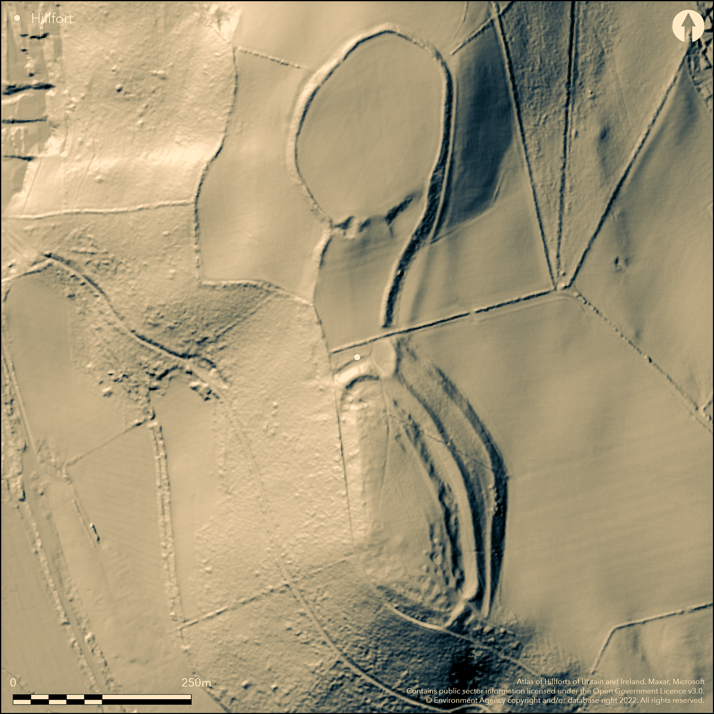
LiDAR 1m DTM Hillshade
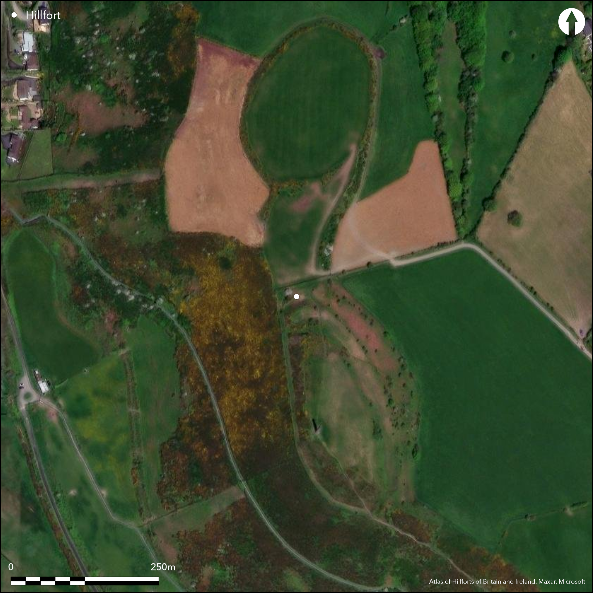
Satellite Imagery
LiDAR 1m DTM Hillshade
Satellite Imagery
Scroll left/right to view further images.
HER: Dyfed 3993 (None)
NMR: SN 58 SE (92236)
SM: None
NGR: SN58418036
X: 258410 Y: 280360 (OSGB36)
Major contour hillfort, with two distinct enclosures to N and S, located on prominent hilltop overlooking the bay and estuary of the Afon Ystwyth to SW and Afon Rheidol to E at Aberystwth and linked by saddle of ground called 'the isthmus'. Surrounding slopes steep to N, very steep to S and W and moderate to strong to E. Four phased construction defined by excavations 1933-37 of C. Daryll Forde, started middle Iron Age. First phase N enclosure of 1.72 ha defended by a rampart of packed rubble with timber revetment and outer ditch. Second phase of S enclosure of 2.28 ha defended by a bank revetted with stone with outer ditch and elaborate gate, later collapsed and site abandoned. Later reoccupied and ramparts remodelled in Phase 3. Finally enclosed area had additional ramparts constructed across the isthmus linking both summits, together with a new main gate as Phase 4 and site now extended to 4.4 ha in total. C. 12 hut platforms (most for circular buildings, but one excavated was D-shaped), cut into hillside in S enclosure, mostly around S gate. Good condition, but ploughed and farmed interior to N and rough pasture and scrub to S enclosure which has public access - N enclosure private. 19th century Wellington monument in S enclosure. Setting affected by development, especially when seen from S. On 1st Ed. OS map (1889).
Citizen Science: ✗
Reliability of Data: Confirmed
Reliability of Interpretation: Confirmed
X: -454489 Y: 6873297 (EPSG: 3857)
Longitude: -4.082744476832121 Latitude: 52.4028528439903 (EPSG:4326)
Country: Wales
Current County or Unitary Authority: Ceredigion
Historic County: Cardiganshire
Current Parish/Community/Council/Townland: Aberystwyth
Good condition, but ploughed and farmed interior to N and S enclosure ploughed in historic times. S enclosure has public access - N enclosure private. Wellington monument in S enclosure. Setting affected by development, especially when seen from S.
| Extant | ✓ |
| Cropmark | ✗ |
| Likely Destroyed | ✗ |
Farmed to N, rough pasture and scrub to S. Wellington monument.
| Woodland | ✗ |
| Commercial Forestry Plantation | ✗ |
| Parkland | ✗ |
| Pasture (Grazing) | ✓ |
| Arable | ✗ |
| Scrub/Bracken | ✓ |
| Bare Outcrop | ✗ |
| Heather/Moorland | ✗ |
| Heath | ✗ |
| Built-up | ✗ |
| Coastal Grassland | ✗ |
| Other | ✓ |
Major hillfort with two distinct enclosures (north and south) on a prominent hilltop overlooking the bay and estuary of the Afon Ystwyth to the southwest and Afon Rheidol to the east. Phased
| Contour Fort | ✓ |
| Partial Contour Fort | ✗ |
| Promontory Fort | ✗ |
| Hillslope Fort | ✗ |
| Level Terrain Fort | ✗ |
| Marsh Fort | ✗ |
| Multiple Enclosure Fort | ✗ |
| Hilltop | ✓ |
| Coastal Promontory | ✗ |
| Inland Promontory | ✗ |
| Valley Bottom | ✗ |
| Knoll/Hillock/Outcrop | ✗ |
| Ridge | ✗ |
| Cliff/Plateau-edge/Scarp | ✗ |
| Hillslope | ✗ |
| Lowland | ✗ |
| Spur | ✗ |
Dominant Topographic Feature: Hill top.
| North | ✗ |
| Northeast | ✗ |
| East | ✗ |
| Southeast | ✗ |
| South | ✗ |
| Southwest | ✗ |
| West | ✗ |
| Northwest | ✗ |
| Level | ✓ |
Altitude: 114.0m
N/A
Bronze Age barrow on the site. Iron Age jar with stamped decoration c. 100BC similar to 'Malvernian' pottery found on the Welsh borders and 4th century AD Roman coin of Maximian (AD 307) suggest long interest and use.
Reliability: B - Medium
| Pre 1200BC | ✗ |
| 1200BC - 800BC | ✗ |
| 800BC - 400BC | ✗ |
| 400BC - AD50 | ✓ |
| AD50 - AD400 | ✓ |
| AD400 - AD 800 | ✗ |
| Post AD800 | ✗ |
| Unknown | ✗ |
| Pre Hillfort: | None |
| Post Hillfort: | None |
| Artefactual: | Pottery and coin. |
On 1st Ed. OS map (1889). C. Daryll Forde 1933-7 investigated limited parts of the fort, Cambria Archaeology defended enclosures survey 2006.
| 1st Identified Map Depiction (1889): | OS map. |
| Other (2006): | Cambria Archaeology defended enclosures survey. |
| Excavation (None): | C. Daryll Forde. |
Hut platforms (most for circular buildings), but one excavated was D-shaped), cut into hillside in S enclosure, mostly around S gate. Iron Age jar with stamped decoration c. 100BC similar to 'Malvernian' pottery found on the Welsh borders. Fine glass bead nera N gateway of S fort, of a pale yellow, translucent colour decorated with three spirals of yellow, opaque glass thread. Other finds stone bead, two spindlewhorls, two loom weights, fragments of corroded iron and bronze, and a cache of over one hundred slingstones from excavation and chance finds 1999. Also Neolithic stone axe, Bronze Age palstave and triangular barbed and tanged arrowhead. Chance find of late Roman coin of Maximian (AD 307). Sword of uncertain date was found on the lower slopes of S fort. Spearhead and Medieval coin. More recently, further slingstones have come to light in various parts of the south fort following the bracken fire of 1999.
Afon Ystwyth 0.4km outside fort.
| None | ✓ |
| Spring | ✗ |
| Stream | ✗ |
| Pool | ✗ |
| Flush | ✗ |
| Well | ✗ |
| Other | ✗ |
Hut platforms (most for circular buildings), but one excavated was D-shaped), cut into hillside in S enclosure, mostly around S gate.
| No Known Features | ✗ |
| Round Stone Structures | ✗ |
| Rectangular Stone Structures | ✗ |
| Curvilinear Platforms | ✓ |
| Other Roundhouse Evidence | ✗ |
| Pits | ✗ |
| Quarry Hollows | ✗ |
| Other | ✗ |
D-shaped hut platform, cut into hillside in S enclosure excavated.
| No Known Excavation | ✗ |
| Pits | ✗ |
| Postholes | ✗ |
| Roundhouses | ✗ |
| Rectangular Structures | ✗ |
| Roads/Tracks | ✗ |
| Quarry Hollows | ✗ |
| Other | ✓ |
| Nothing Found | ✗ |
None
| No Known Geophysics | ✓ |
| Pits | ✗ |
| Roundhouses | ✗ |
| Rectangular Structures | ✗ |
| Roads/Tracks | ✗ |
| Quarry Hollows | ✗ |
| Other | ✗ |
| Nothing Found | ✗ |
Iron Age jar with stamped decoration c. 100BC similar to 'Malvernian' pottery found on the Welsh borders. Fine glass bead nera N gateway of S fort, of a pale yellow, translucent colour decorated with three spirals of yellow, opaque glass thread. Other finds stone bead, two spindlewhorls, two loom weights, fragments of corroded iron and bronze, and a cache of over one hundred slingstones from excavation and chance finds 1999. Also Neolithic stone axe, Bronze Age palstave and triangular barbed and tanged arrowhead. Chance find of late Roman coin of Maximian (AD 307). Sword of uncertain date was found on the lower slopes of S fort. Spearhead and Medieval coin. More recently, further slingstones have come to light in various parts of the south fort following the bracken fire of 1999.
| No Known Finds | ✗ |
| Pottery | ✓ |
| Metal | ✗ |
| Metalworking | ✗ |
| Human Bones | ✗ |
| Animal Bones | ✗ |
| Lithics | ✗ |
| Environmental | ✗ |
| Other | ✓ |
None
| APs Not Checked | ✓ |
| None | ✗ |
| Roundhouses | ✗ |
| Rectangular Structures | ✗ |
| Pits | ✗ |
| Postholes | ✗ |
| Roads/Tracks | ✗ |
| Other | ✗ |
N enclosure has an inturned entrance to S. S enclosure had entrances to S and N. Elaborate S gate later collapsed. The later stone-walled isthmus gate on N stood as high as a two-storey building and was crossed by a wooden bridge supported on four massive timber posts (Driver RCAHMW Coflein).
| 3: | None |
| 2: | None |
Guard Chambers: ✗
Chevaux de Frise: ✗
| 1. In-turned (South): | N enclosure gate. |
| 2. Other Forms (South): | Elaborate S enclosure gate, later collapsed. |
| 3. Other Forms (North): | Fine S enclosure isthmus gate crossed by wooden bridge. |
First phase N enclosure of 1.72 ha defended by a stone bank of packed rubble with timber revetment and outer ditch. Second phase of S enclosure of 2.28 defended by a bank revetted with stone with outer ditch and elaborate gate, later collapsed and site abandoned. Later r-occupied and defences remodelled in Phase 3. Finally defended area had additional ramparts constructed across the isthmus linking both summits, together with a new main gate as Phase 4 and site now extended to 4.4 ha in total.
| Area 1: | 1.72ha. |
| Area 2: | 2.28ha. |
| Area 3: | 4.4ha. |
| Total: | 4.4ha. |
Total Footprint Area: Noneha.
None
| ✓ | Four phases determined by Daryll Forde in 1933-37 excavations. |
| ✓ | None |
| NE Quadrant: | 1 |
| SE Quadrant: | 1 |
| SW Quadrant: | 1 |
| NW Quadrant: | 1 |
| Total: | 1 |
| Partial Univallate | ✗ |
| Univallate | ✓ |
| Partial Bivallate | ✗ |
| Bivallate | ✗ |
| Partial Multivallate | ✗ |
| Multivallate | ✗ |
| Unknown | ✗ |
| Partial Univallate | ✗ |
| Univallate | ✗ |
| Partial Bivallate | ✗ |
| Bivallate | ✗ |
| Partial Multivallate | ✗ |
| Multivallate | ✗ |
Stone-walled site of varying constructions.
| None | ✗ |
| Earthen Bank | ✗ |
| Stone Wall | ✓ |
| Rubble | ✗ |
| Wall-walk | ✗ |
| Evidence of Timber | ✗ |
| Vitrification | ✗ |
| Other Burning | ✗ |
| Palisade | ✗ |
| Counter Scarp Bank | ✗ |
| Berm | ✗ |
| Unfinished | ✗ |
| Other | ✗ |
First phase N enclosure rampart of packed rubble with timber revetment and outer ditch. Second phase S enclosure of 2.28 defended by a bank revetted with stone with outer ditch. Later r-occupied and defences remodelled in Phase 3. Finally defended area had additional ramparts constructed across the isthmus linking both summits, together with a new main gate, as Phase 4.
| None | ✗ |
| Earthen Bank | ✓ |
| Stone Wall | ✓ |
| Murus Duplex | ✗ |
| Timber-framed | ✓ |
| Timber-laced | ✗ |
| Vitrification | ✗ |
| Other Burning | ✗ |
| Palisade | ✗ |
| Counter Scarp Bank | ✗ |
| Berm | ✗ |
| Unfinished | ✗ |
| No Known Excavation | ✗ |
| Other | ✗ |
| ✗ | None |
| ✓ | Ditch to both enclosures. |
Number of Ditches: 2
| ✗ | None |
Avery, M, 1993, `Pen Dinas' in Hillfort Defences of Southern Britain, BAR British Series 231, Volume II, Appendix A, The Evidence of Individual Sites, 255-263. (part of: Avery, M. 1993. Hillfort Defences of Southern Britain, BAR British Series 231, (three volumes)).
Browne, D. and Driver, T., 2001. Bryngaer Pen Dinas Hill-fort, A Prehistoric Fortress at Aberystwyth, Aberystwyth: RCAHMW.
Driver, T., 2005. The Hillforts of North Ceredigion: Architecture, Landscape Setting and Cultural Contexts, Unpublished PhD thesis, The University of Wales, Lampeter, Department of Archaeology and Anthropology.
Driver, T. 2013. Architecture, Regional Identity and Power in the Iron Age Landscapes of Mid Wales: The Hillforts of North Ceredigion, BAR British Series 583, Oxford: Archaeopress.
Forde, D. 1937. Note - Excavations at Pen Dinas, Cardiganshire, 1937, Ant J, Vol. XVIII, No.1.
Forde, D., Griffiths, W.E, Hogg, A.H.A. and Houlder, C. 1963. Excavations at Pen Dinas, Aberystwyth, Arch Camb, 112, 125-53.
Hogg, A.H.A. 1962. List of hill-forts in Cardiganshire, Bull Board Celtic Stud, 19, 358.
Murphy, K, Ramsey, R. and Page, M. 2006. A survey of defended enclosures in Ceredigion 2006: Gazetteer of Ordnance Survey Grid Squares SN58, Project Report No. 2006/20, Project Record No. 54269, Llandeilo: Cambria Archaeology.
Rees, S. 1992. A guide to ancient and historic Wales - Dyfed, London: HMSO, 88-9.
Atlas of Hillforts:
Wikidata:
This work is licensed under CC BY-SA 4.0

 and should be cited as:
Lock, Gary and Ralston, Ian. 2024. Atlas of Hillforts of Britain and Ireland. Available at: https://hillforts.arch.ox.ac.uk
Document Version 1.1