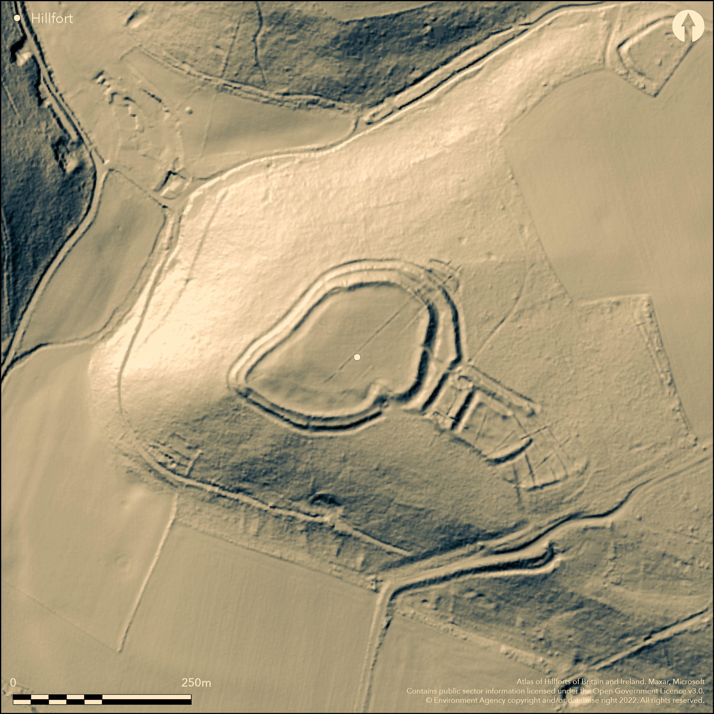
LiDAR 1m DTM Hillshade
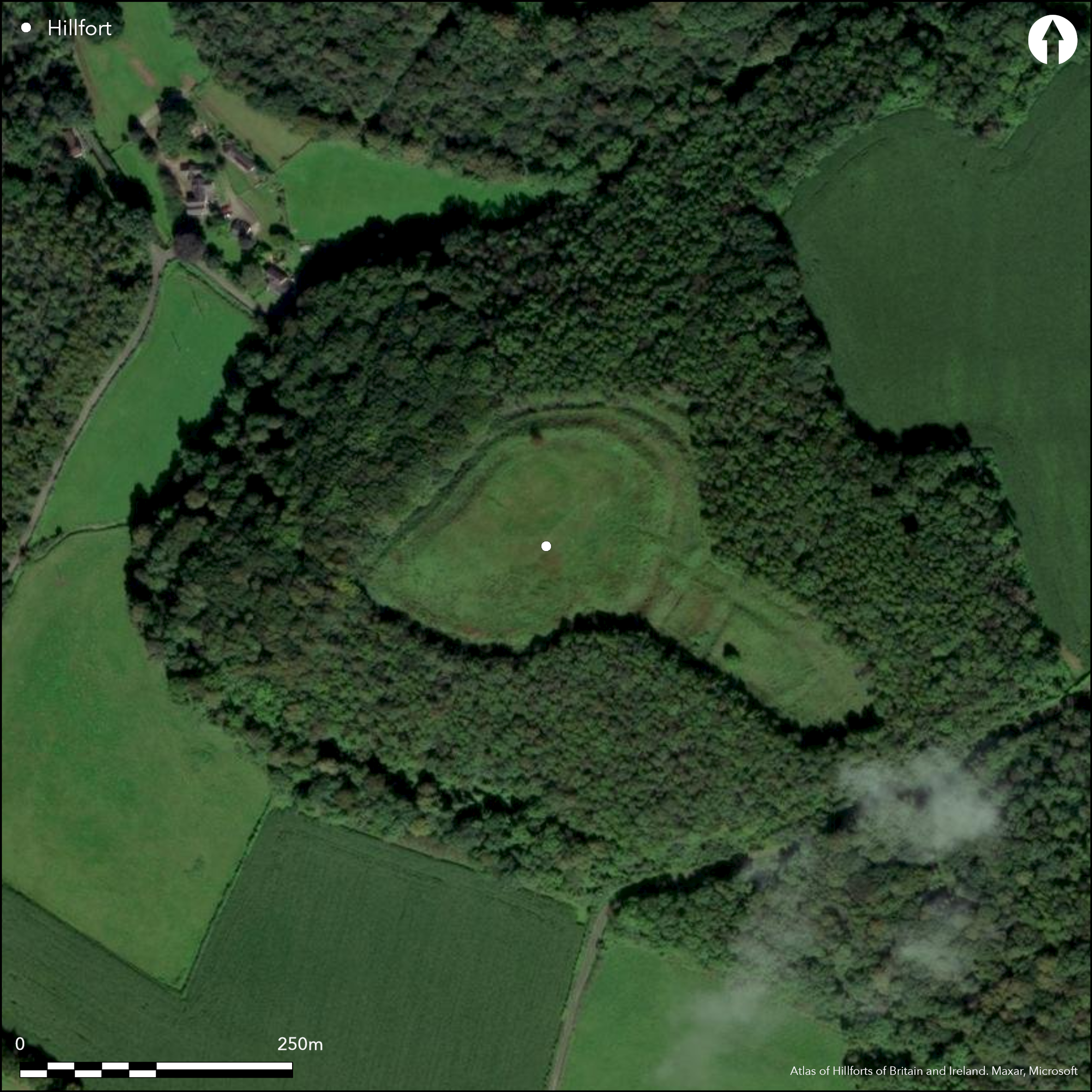
Satellite Imagery
LiDAR 1m DTM Hillshade
Satellite Imagery
Scroll left/right to view further images.
HER: Glamorgan Gwent 01026g (None)
NMR: ST 49 SE 1 (301559; 307960)
SM: MM024
NGR: ST46109257
X: 346100 Y: 192570 (OSGB36)
Wooded, complex of excavated enclosures in the hills behind the coastal plain overlooking the Severn Estuary. Main contour hillfort and nearby 'Outpost'. Surrounding slopes N moderate to strong, S and E steep, E moderate. A main, roughly elliptical enclosure, has two and three ramparts, highest on the SE near the entrance and measures c. 230m by 150m, with internal area of 1.32ha. Excavated by Nash-Williams 1930-32. To SE is a complex of rectangular annexes with entrance only on the outermost one, with a rectangular multivallate annexe (c. 40m by 21m) against SE long side. Single inturned entrance to site immediately S of junction between main enclosure and annexe. Rock-cut ditches and banks mainly up-cast, although on NE side innermost bank wholly of rubble and faced with roughly-coursed masonry both internally and externally. SW bank rubble revetment. At least one inner earthwork of annexe secondary. Trackway, probably contemporary, led from close to the S corner of the annexe W obliquely down the hill. Phased construction, the earliest being a single bank and ditch enclosure of the 3rd century BC. The main enclosure was then constructed circa 150 BC. Remodelling circa 50 BC with construction of the annexes and strengthening of entrance. To NE is a smaller c-shaped enclosure with double bank - the so-called 'Outpost'. Little occupation deposits found in either enclosure. Early Iron Age and Roman pottery, none of the latter later than c. AD 75. On this basis, Nash-Williams (1933) stated that Roman occupation could not have extended beyond AD 75, but this is open to doubt. Both annexe to main fort and the 'Outpost', contained medieval buildings associated with late 12th - early 13th century pottery. One-roomed structures of rectangular plan with rounded corners, type recorded in South Wales throughout medieval period, and used for buildings on manorial sites as well as for peasants' cottages. Community excavations of part of interior by CADW 2013. On 1st Ed. OS map (1882).
Citizen Science: ✗
Reliability of Data: Confirmed
Reliability of Interpretation: Confirmed
X: -309483 Y: 6733374 (EPSG: 3857)
Longitude: -2.78013187083946 Latitude: 51.62930274091732 (EPSG:4326)
Country: Wales
Current County or Unitary Authority: Monmouth
Historic County: Monmouthshire
Current Parish/Community/Council/Townland: Shirenewton
Near intact.
| Extant | ✓ |
| Cropmark | ✗ |
| Likely Destroyed | ✗ |
Wooded slopes, pasture interior to main site. Medieval structure.
| Woodland | ✓ |
| Commercial Forestry Plantation | ✗ |
| Parkland | ✗ |
| Pasture (Grazing) | ✓ |
| Arable | ✗ |
| Scrub/Bracken | ✗ |
| Bare Outcrop | ✗ |
| Heather/Moorland | ✗ |
| Heath | ✗ |
| Built-up | ✗ |
| Coastal Grassland | ✗ |
| Other | ✓ |
Wooded, complex of excavated enclosures in the hills behind the coastal plain overlooking the Severn Estuary. Surrounding slopes N moderate to strong, S and E steep, E moderate. Main site contour hillfort at c. 104m O.D., 'Outpost' at c. 95m O.D.
| Contour Fort | ✓ |
| Partial Contour Fort | ✗ |
| Promontory Fort | ✗ |
| Hillslope Fort | ✗ |
| Level Terrain Fort | ✗ |
| Marsh Fort | ✗ |
| Multiple Enclosure Fort | ✗ |
| Hilltop | ✓ |
| Coastal Promontory | ✗ |
| Inland Promontory | ✗ |
| Valley Bottom | ✗ |
| Knoll/Hillock/Outcrop | ✗ |
| Ridge | ✗ |
| Cliff/Plateau-edge/Scarp | ✗ |
| Hillslope | ✗ |
| Lowland | ✗ |
| Spur | ✗ |
Dominant Topographic Feature: Hill top
| North | ✗ |
| Northeast | ✗ |
| East | ✗ |
| Southeast | ✗ |
| South | ✗ |
| Southwest | ✗ |
| West | ✗ |
| Northwest | ✗ |
| Level | ✓ |
Altitude: 104.0m
N/A
Excavated early Iron Age and Roman pottery, none of the latter later than c. AD 75.
Reliability: B - Medium
| Pre 1200BC | ✗ |
| 1200BC - 800BC | ✗ |
| 800BC - 400BC | ✓ |
| 400BC - AD50 | ✓ |
| AD50 - AD400 | ✗ |
| AD400 - AD 800 | ✗ |
| Post AD800 | ✗ |
| Unknown | ✗ |
| Pre Hillfort: | None |
| Post Hillfort: | None |
| Artefactual: | Early Iron Age and Roman pottery, non of latter later than c. 75 AD. |
On 1st Ed. OS map (1882). Excavations by Nash-Williams 1930-32. GGAT Prehistoric defended enclosures in Glamorgan survey 2005. Community excavations by CADW 2013.
| 1st Identified Map Depiction (1882): | OS map. |
| Other (1991): | Visited by Hillfort Study Group |
| Other (2005): | GGAT Prehistoric defended enclosures in Glamorgan survey. |
| Excavation (2013): | CADW community excavation - no details. |
| Excavation (None): | Nash-Williams. |
Early Iron Age and Roman pottery. Animal bones, metal working and range of finds from 2013 excavations.
Stream 0.15km outside fort.
| None | ✓ |
| Spring | ✗ |
| Stream | ✗ |
| Pool | ✗ |
| Flush | ✗ |
| Well | ✗ |
| Other | ✗ |
None
| No Known Features | ✓ |
| Round Stone Structures | ✗ |
| Rectangular Stone Structures | ✗ |
| Curvilinear Platforms | ✗ |
| Other Roundhouse Evidence | ✗ |
| Pits | ✗ |
| Quarry Hollows | ✗ |
| Other | ✗ |
None
| No Known Excavation | ✗ |
| Pits | ✗ |
| Postholes | ✗ |
| Roundhouses | ✗ |
| Rectangular Structures | ✗ |
| Roads/Tracks | ✗ |
| Quarry Hollows | ✗ |
| Other | ✗ |
| Nothing Found | ✓ |
None
| No Known Geophysics | ✓ |
| Pits | ✗ |
| Roundhouses | ✗ |
| Rectangular Structures | ✗ |
| Roads/Tracks | ✗ |
| Quarry Hollows | ✗ |
| Other | ✗ |
| Nothing Found | ✗ |
Early Iron Age and Roman pottery.
| No Known Finds | ✗ |
| Pottery | ✓ |
| Metal | ✗ |
| Metalworking | ✓ |
| Human Bones | ✗ |
| Animal Bones | ✓ |
| Lithics | ✗ |
| Environmental | ✗ |
| Other | ✓ |
None
| APs Not Checked | ✓ |
| None | ✗ |
| Roundhouses | ✗ |
| Rectangular Structures | ✗ |
| Pits | ✗ |
| Postholes | ✗ |
| Roads/Tracks | ✗ |
| Other | ✗ |
To SE is a complex of rectangular annexes with entrance only on the outermost one. Possible part-inturned entrance below annexes on SE - may be modern?
| 1: | None |
| 2: | None |
Guard Chambers: ✗
Chevaux de Frise: ✗
| 1. In-turned (South east): | Possible part-inturned entrance below annexes - may be modern? |
Main, roughly elliptical enclosure, has two and three ramparts, highest on the SE near the entrance.
| Area 1: | 1.32ha. |
| Total: | 1.32ha. |
Total Footprint Area: Noneha.
None
| ✓ | Main enclosure 1.32ha internal area, 'Outpost' 0.14ha internal area. |
| ✓ | Complex of annexes on SE of main enclosure confuse quadrants analysis. |
| NE Quadrant: | 3 |
| SE Quadrant: | 3 |
| SW Quadrant: | 2 |
| NW Quadrant: | 2 |
| Total: | 3 |
| Partial Univallate | ✗ |
| Univallate | ✗ |
| Partial Bivallate | ✓ |
| Bivallate | ✗ |
| Partial Multivallate | ✓ |
| Multivallate | ✗ |
| Unknown | ✗ |
| Partial Univallate | ✗ |
| Univallate | ✓ |
| Partial Bivallate | ✗ |
| Bivallate | ✗ |
| Partial Multivallate | ✗ |
| Multivallate | ✗ |
None
| None | ✗ |
| Earthen Bank | ✓ |
| Stone Wall | ✗ |
| Rubble | ✗ |
| Wall-walk | ✗ |
| Evidence of Timber | ✗ |
| Vitrification | ✗ |
| Other Burning | ✗ |
| Palisade | ✗ |
| Counter Scarp Bank | ✗ |
| Berm | ✗ |
| Unfinished | ✗ |
| Other | ✗ |
Banks mainly up-cast, although on NE side innermost bank wholly of rubble and faced with roughly-coursed masonry both internally and externally.
| None | ✗ |
| Earthen Bank | ✓ |
| Stone Wall | ✓ |
| Murus Duplex | ✗ |
| Timber-framed | ✗ |
| Timber-laced | ✗ |
| Vitrification | ✗ |
| Other Burning | ✗ |
| Palisade | ✗ |
| Counter Scarp Bank | ✗ |
| Berm | ✗ |
| Unfinished | ✗ |
| No Known Excavation | ✗ |
| Other | ✗ |
| ✗ | None |
| ✓ | Rock-cut ditches. |
Number of Ditches: 3
| ✓ | To SE is a complex of rectangular annexes with entrance only on the outermost one, with a rectangular multivallate annexe (c. 40m by 21m) against SE long side. |
Anon. 2013. Llanmelin: Iron Age community research. Current Archaeol, 277, 10.
Forde-Johnston, J. 1976. Hillforts of the Iron Age in England and Wales, Liverpool: Liverpool University Press.
Nash-Williams, V.E. 1933. An early Iron Age hill-fort at Llanmelin, near Caerwent, Monmouthshire, Arc Camb, 88 (1933) 237-315.
Savory, H.N. 1950. List of hill-fort and other earthworks in Wales, II. Monmouthshire, Bull Board Celtic Stud, 13, 233.
Whittle, E. 1992. A guide to ancient and historic Wales - Glamorgan and Gwent, London: HMSO, 48-9.
Atlas of Hillforts:
Wikidata:
This work is licensed under CC BY-SA 4.0

 and should be cited as:
Lock, Gary and Ralston, Ian. 2024. Atlas of Hillforts of Britain and Ireland. Available at: https://hillforts.arch.ox.ac.uk
Document Version 1.1