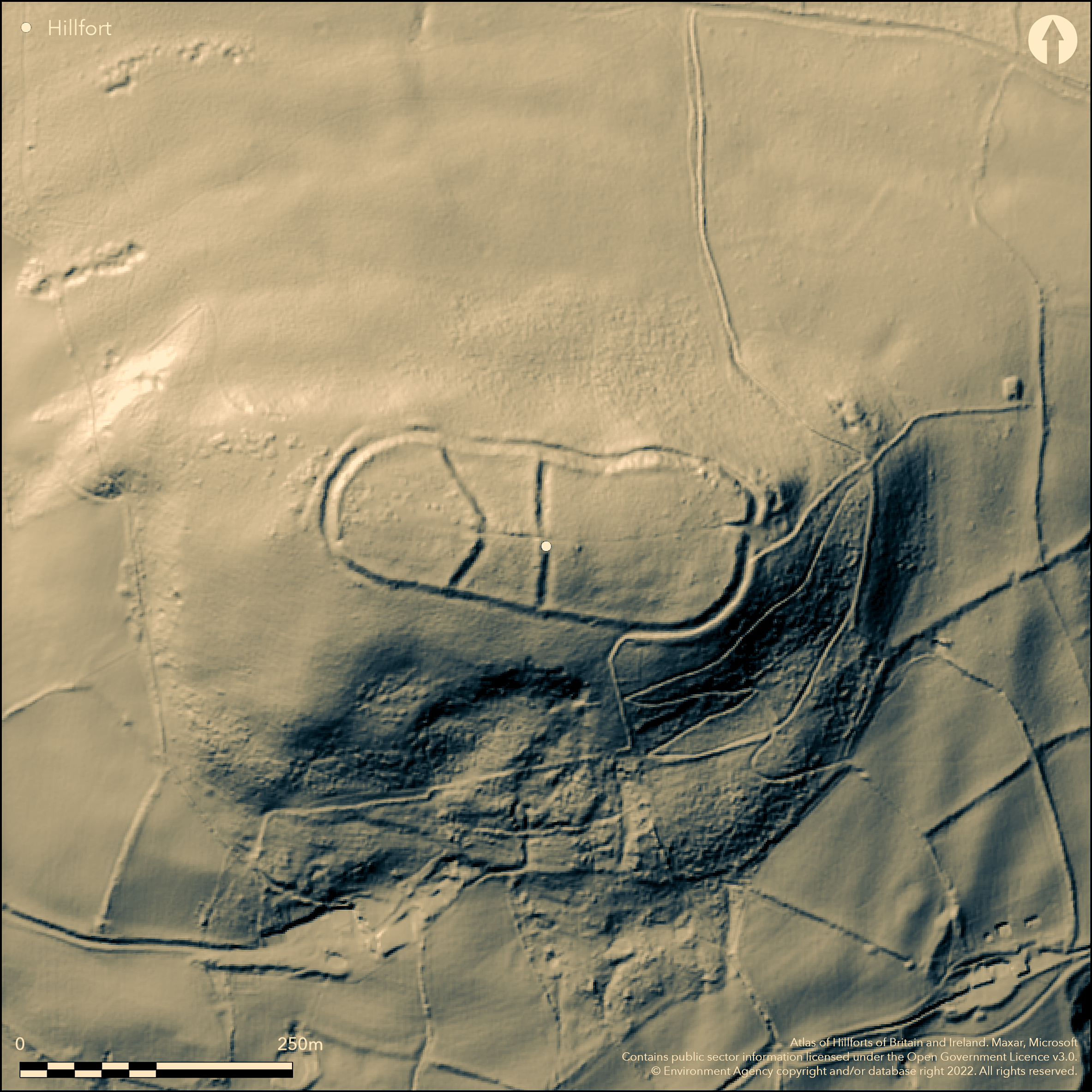
LiDAR 1m DTM Hillshade
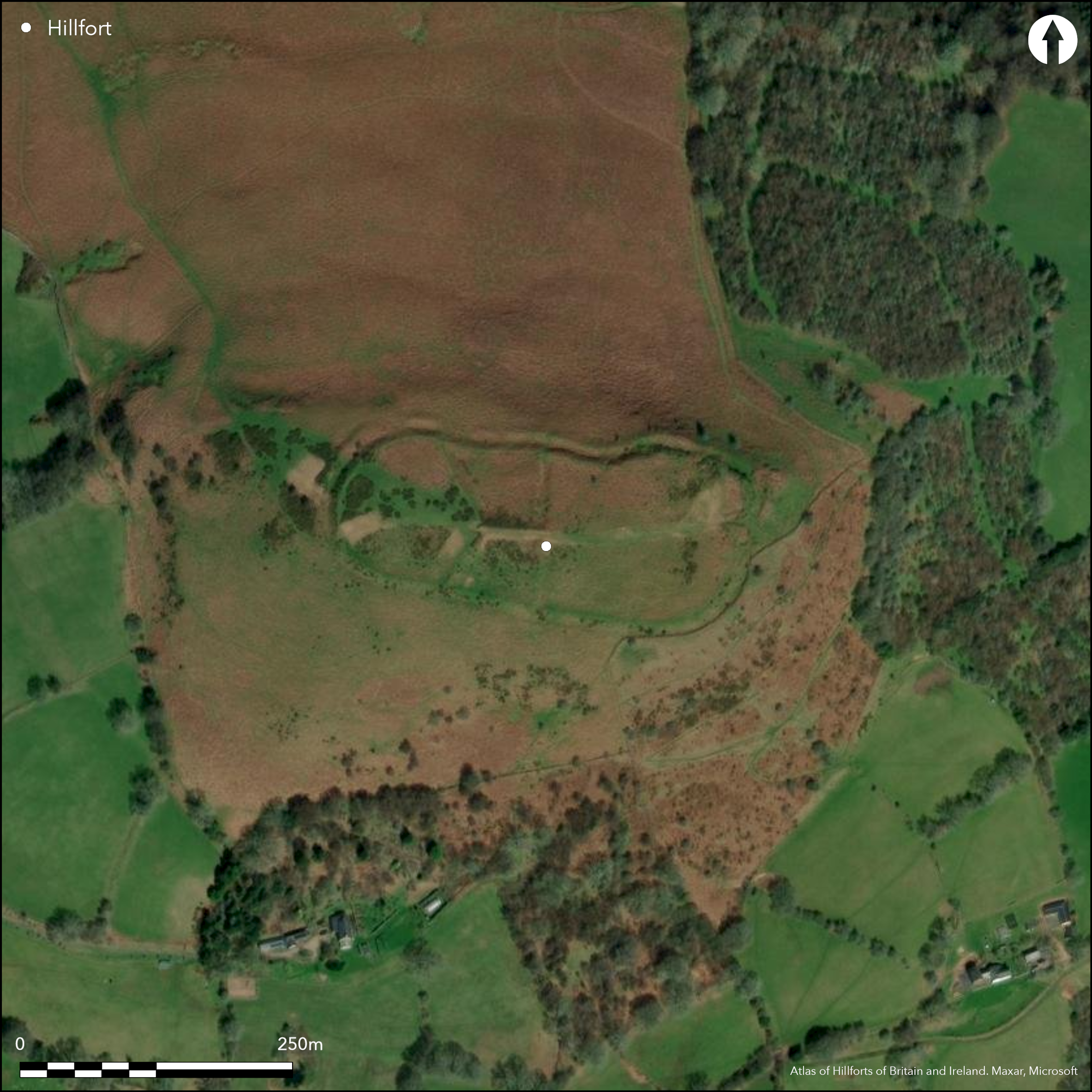
Satellite Imagery
LiDAR 1m DTM Hillshade
Satellite Imagery
Scroll left/right to view further images.
HER: Glamorgan Gwent 01713g (None)
NMR: SO 22 SE (300043)
SM: MM148
NGR: SO29402195
X: 329400 Y: 221950 (OSGB36)
Commanding, excavated contour hillfort located high (426m O.D.) on the interfluve between the Wye catchment and Usk catchments, near the Honddu and Monnow confluence, above the S end of Vale of Ewyas. Surrounding slopes very steep to S, slightly less on N and W and moderate to strong on E, with internal area of 1.8ha. Oblong in shape with long axis aligned E-W. Two cross-bank and ditches running N-S divide the internal area of enclosure into three. Complicated phased construction. Initially, an enclosure with central cross bank and simple gap entrance as its E extremity. Then an E enclosure enclosed by bank and ditch and E entrance built. Finally, the W-most cross bank delineated a smaller fort at this W end. Main bank had a dry-stone revetment with later wall-walk overall, with an outer bank on W. Average width of ramparts and ditches is c. 9.0m. Average overall width of cross-banks and ditches c.12.0m. Banks have strong stone content. Inner banks deteriorated to a scarp across most of the S and SW sides. Simple gap entrance in middle cross bank, the W slightly inturned. E entrance had long passageway revetted in stone, with a gate at the inner end, with refinements and alterations over time. Interior slightly convex, with little surface sign of any features, although few shallow hollows in N area. Excavation (Probert 1976) showed hut platforms and many mostly domestic artefacts with ironworking. First phase of the early Iron Age, with C14 date of c. 400 BC for its end.
Citizen Science: ✗
Reliability of Data: Confirmed
Reliability of Interpretation: Confirmed
X: -337003 Y: 6780544 (EPSG: 3857)
Longitude: -3.0273453920646447 Latitude: 51.89157274785586 (EPSG:4326)
Country: Wales
Current County or Unitary Authority: Monmouth
Historic County: Monmouthshire
Current Parish/Community/Council/Townland: Crucorney
Ramparts not strong but fair preservation. Mostly overgrown piles of stones and once higher and ditches deeper.
| Extant | ✓ |
| Cropmark | ✗ |
| Likely Destroyed | ✗ |
Moorland grazing and scrub.
| Woodland | ✗ |
| Commercial Forestry Plantation | ✗ |
| Parkland | ✗ |
| Pasture (Grazing) | ✗ |
| Arable | ✗ |
| Scrub/Bracken | ✓ |
| Bare Outcrop | ✗ |
| Heather/Moorland | ✓ |
| Heath | ✗ |
| Built-up | ✗ |
| Coastal Grassland | ✗ |
| Other | ✗ |
Excavated contour hillfort located high (426m O.D.) on the interfluve between the Wye catchment and Usk catchments, near the Honddu and Monnow confluence, above theS end of Vale of Ewyas. IIn a commanding position. Surrounding slopes very steep to S, slightly less on N and W and moderate to strong on E.
| Contour Fort | ✓ |
| Partial Contour Fort | ✗ |
| Promontory Fort | ✗ |
| Hillslope Fort | ✗ |
| Level Terrain Fort | ✗ |
| Marsh Fort | ✗ |
| Multiple Enclosure Fort | ✗ |
| Hilltop | ✓ |
| Coastal Promontory | ✗ |
| Inland Promontory | ✗ |
| Valley Bottom | ✗ |
| Knoll/Hillock/Outcrop | ✗ |
| Ridge | ✗ |
| Cliff/Plateau-edge/Scarp | ✗ |
| Hillslope | ✗ |
| Lowland | ✗ |
| Spur | ✗ |
Dominant Topographic Feature: Hill top
| North | ✗ |
| Northeast | ✗ |
| East | ✗ |
| Southeast | ✗ |
| South | ✗ |
| Southwest | ✗ |
| West | ✗ |
| Northwest | ✗ |
| Level | ✓ |
Altitude: 426.0m
N/A
First phase of the early Iron Age, with C14 date of c. 400 BC for its end.
Reliability: B - Medium
| Pre 1200BC | ✗ |
| 1200BC - 800BC | ✗ |
| 800BC - 400BC | ✓ |
| 400BC - AD50 | ✗ |
| AD50 - AD400 | ✗ |
| AD400 - AD 800 | ✗ |
| Post AD800 | ✗ |
| Unknown | ✗ |
| Pre Hillfort: | None |
| Post Hillfort: | None |
| C14: | C14 date of c. 400 BC for end. |
Excavation by A. Probert 1965-1970's? GGAT Prehistoric defended enclosures in Glamorgan survey 2005.
| Other (1982): | Visited by Hillfort Study Group |
| Other (2005): | GGAT survey. |
| Excavation (None): | A. Probert |
Shallow hollows in N area - uncertain features. No visible surface trace of internal habitations. Excavation showed hut platforms and many mostly domestic finds with ironworking, including La Tene style brooches, querns (saddle and beehive) decorative beads, spindle whorls, flints, crucibles and clay ovens. Also a metal spearhead and a metal pin thought to be a carriage pin. Evidence of metal working. Two apparent size contractions identified from a private aerial photograph taken in 1999 (HER refers).
Afon Grwynne 0.65km.
| None | ✓ |
| Spring | ✗ |
| Stream | ✗ |
| Pool | ✗ |
| Flush | ✗ |
| Well | ✗ |
| Other | ✗ |
Shallow hollows in N area - uncertain features.
| No Known Features | ✗ |
| Round Stone Structures | ✗ |
| Rectangular Stone Structures | ✗ |
| Curvilinear Platforms | ✗ |
| Other Roundhouse Evidence | ✗ |
| Pits | ✗ |
| Quarry Hollows | ✗ |
| Other | ✓ |
Excavation showed hut platforms; possibly roundhouses?
| No Known Excavation | ✗ |
| Pits | ✗ |
| Postholes | ✗ |
| Roundhouses | ✓ |
| Rectangular Structures | ✗ |
| Roads/Tracks | ✗ |
| Quarry Hollows | ✗ |
| Other | ✓ |
| Nothing Found | ✗ |
None
| No Known Geophysics | ✓ |
| Pits | ✗ |
| Roundhouses | ✗ |
| Rectangular Structures | ✗ |
| Roads/Tracks | ✗ |
| Quarry Hollows | ✗ |
| Other | ✗ |
| Nothing Found | ✗ |
Domestic artefacts including La Tene style brooches, querns (saddle and beehive) decorative beads, spindle whorls, flints, crucibles and clay ovens. Also a metal spearhead and a metal pin thought to be a carriage pin. Evidence of metal working.
| No Known Finds | ✗ |
| Pottery | ✗ |
| Metal | ✗ |
| Metalworking | ✓ |
| Human Bones | ✗ |
| Animal Bones | ✗ |
| Lithics | ✓ |
| Environmental | ✗ |
| Other | ✓ |
Two apparent size contractions identified from a private aerial photograph taken in 1999 (HER refers).
| APs Not Checked | ✗ |
| None | ✗ |
| Roundhouses | ✗ |
| Rectangular Structures | ✗ |
| Pits | ✗ |
| Postholes | ✗ |
| Roads/Tracks | ✗ |
| Other | ✓ |
E bank has a simple 9m wide entrance, the W, more curved like a passage entrance, curving to the W and with a 7m wide gap.
| 2: | None |
| 2: | None |
Guard Chambers: ✗
Chevaux de Frise: ✗
| 1. Simple Gap (East): | None |
| 2. Passage-way/Corridor (West): | None |
Two cross-bank and ditches running N-S divide the internal area of enclosure into three. Complicated phased construction. Initially, an enclosure with central cross bank and simple gap entrance as its E extremity. Then an E enclosure enclosed by bank and ditch and E entrance built. Finally, the W-most cross bank delineated a smaller fort at this W end. Main bank had a dry-stone revetment with later wall-walk overall, with an outer bank on W. Average width of ramparts and ditches is c. 9.0m. Average overall width of cross-banks and ditches c.12.0m. Banks have strong stone content. Inner banks deteriorated to a scarp across most of the S and SW sides.
| Area 1: | 1.8ha. |
| Total: | 1.8ha. |
Total Footprint Area: Noneha.
None
| ✓ | Complicated phased construction. |
| ✓ | None |
| NE Quadrant: | 1 |
| SE Quadrant: | 1 |
| SW Quadrant: | 2 |
| NW Quadrant: | 2 |
| Total: | 2 |
| Partial Univallate | ✓ |
| Univallate | ✗ |
| Partial Bivallate | ✓ |
| Bivallate | ✗ |
| Partial Multivallate | ✗ |
| Multivallate | ✗ |
| Unknown | ✗ |
| Partial Univallate | ✗ |
| Univallate | ✓ |
| Partial Bivallate | ✗ |
| Bivallate | ✗ |
| Partial Multivallate | ✗ |
| Multivallate | ✗ |
Wall-walk over main bank.
| None | ✗ |
| Earthen Bank | ✗ |
| Stone Wall | ✗ |
| Rubble | ✗ |
| Wall-walk | ✓ |
| Evidence of Timber | ✗ |
| Vitrification | ✗ |
| Other Burning | ✗ |
| Palisade | ✗ |
| Counter Scarp Bank | ✗ |
| Berm | ✗ |
| Unfinished | ✗ |
| Other | ✗ |
Main bank had a dry-stone revetment with later wall-walk overall, with an outer bank on W.
| None | ✗ |
| Earthen Bank | ✓ |
| Stone Wall | ✓ |
| Murus Duplex | ✗ |
| Timber-framed | ✗ |
| Timber-laced | ✗ |
| Vitrification | ✗ |
| Other Burning | ✗ |
| Palisade | ✗ |
| Counter Scarp Bank | ✗ |
| Berm | ✗ |
| Unfinished | ✗ |
| No Known Excavation | ✗ |
| Other | ✓ |
| ✗ | None |
| ✓ | None |
Number of Ditches: 2
| ✗ | None |
Gerrard, C., Wiggins, H., and Evans, E. 2006. Prehistoric defended enclosures in Glamorgan with recommendations for fieldwork: Year 3 Report, GGAT Report No. 2006/089, Project No. GGAT78, Swansea: GGAT.
Howell, R. 2006: Searching for the Silures. An Iron Age tribe in south-east Wales, Stroud: Tempus.
Probert, A. 1976. Twyn-y-Gaer hill-fort, Gwent: an interim assessment, in Boon, G.C. and Lewis, J.M. (eds.), Welsh antiquity, essays presented to Dr H.N. Savory, Cardiff: National Museum of Wales, 105-20.
Savory, H.N. 1950. List of hill-fort and other earthworks in Wales, II. Monmouthshire, Bull Board Celtic Stud, 13, 234.
Whittle 1992: A guide to ancient and historic Wales - Glamorgan and Gwent, London: HMSO, 43.
Atlas of Hillforts:
Wikidata:
This work is licensed under CC BY-SA 4.0

 and should be cited as:
Lock, Gary and Ralston, Ian. 2024. Atlas of Hillforts of Britain and Ireland. Available at: https://hillforts.arch.ox.ac.uk
Document Version 1.1