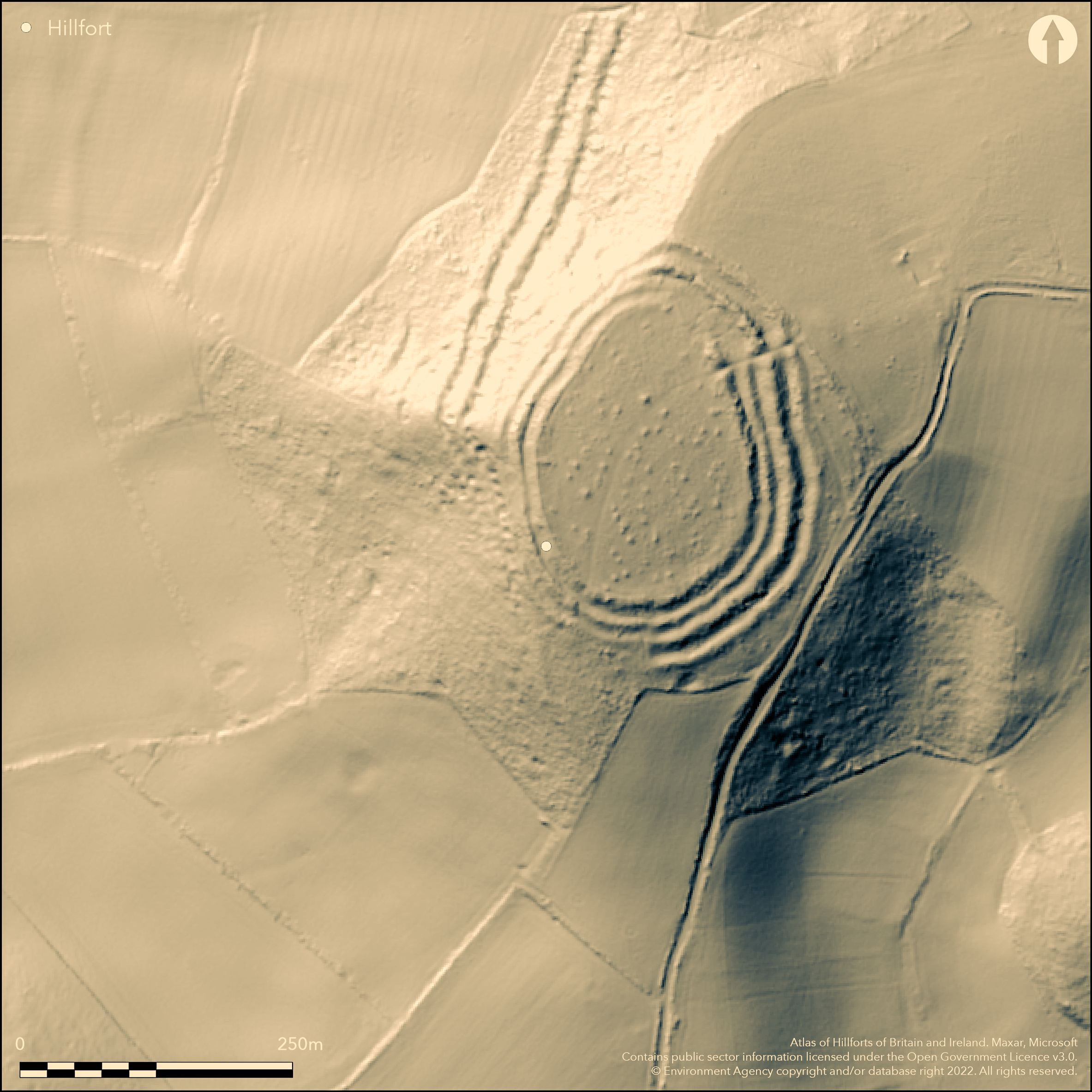
LiDAR 1m DTM Hillshade
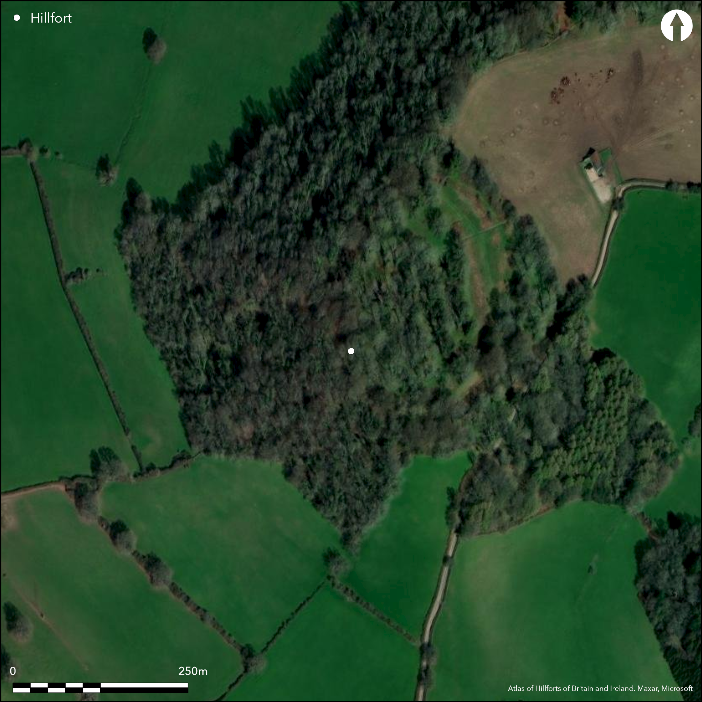
Satellite Imagery
LiDAR 1m DTM Hillshade
Satellite Imagery
Scroll left/right to view further images.
HER: Glamorgan Gwent 0217g (None)
NMR: SO 30 NE 36 (306420)
SM: MM075
NGR: SO365068
X: 336500 Y: 206800 (OSGB36)
Important, excavated, multivallate contour hillfort located on S tip of Clytha Hill above the River Usk, just S of significant bend in the river. Commanding position. Surrounding slopes very steep to N and W, steep to S, moderate to strong to E. Interior generally flat. Circular in form, c. 170m by 114m with internal area of 1.22ha. Ramparts on all but the very steep NW side. Two, three or four ramparts, best on E. The hillfort was partly excavated by K. Babbidge in 1969-1971. Speculation that parts are unfinished. Inner (now a mere scarp) originally a clay bank with stone footing where excavated on S side. On the NE side inner bank revetted on the outside with turf wall and stone footings and on the inside with timber posts and fence. Walkway on top. Single bank and berm on S and W, three banks and ditches culminating at the entrance on facing the more accessible NE side where protected by curved outlying bank, now much reduced. Three banks on N and four on S side of this entrance. Here first and second banks inturned, and possible guardhouse remains on a slight platform on first bank. Possible undefined mound at entrance (not tumulus). Much evidence of Iron Age occupation behind ramparts. with four roundhouses excavated of wattle and daub on stone and clay base. Medieval longhouse was discovered. Excavation also revealed that inner rampart at S constructed in two phases - both with occupation layers. Primary rampart associated with rectangular building measuring 3m by 2m with a second phase with round house 9m in diameter. Rampart to N of entrance also excavated and of one phase. Turf-faced with timber revetment to rear and deliberately levelled. To rear of inner rampart was a round house, 9m in diameter, of two phases and burnt down at end of second phase, the wattle and daub wall preserved in situ. C14 date of second phase of round house gave date of c. 2350 BP. Site wooded. On 1st Ed. OS map (1882).
Citizen Science: ✗
Reliability of Data: Confirmed
Reliability of Interpretation: Confirmed
X: -325209 Y: 6756168 (EPSG: 3857)
Longitude: -2.9214039768105926 Latitude: 51.75622989218161 (EPSG:4326)
Country: Wales
Current County or Unitary Authority: Monmouth
Historic County: Monmouthshire
Current Parish/Community/Council/Townland: Llanarth
Good condition.
| Extant | ✓ |
| Cropmark | ✗ |
| Likely Destroyed | ✗ |
Wooded, except on NE where rough grass and scrub.
| Woodland | ✓ |
| Commercial Forestry Plantation | ✗ |
| Parkland | ✗ |
| Pasture (Grazing) | ✓ |
| Arable | ✗ |
| Scrub/Bracken | ✓ |
| Bare Outcrop | ✗ |
| Heather/Moorland | ✗ |
| Heath | ✗ |
| Built-up | ✗ |
| Coastal Grassland | ✗ |
| Other | ✗ |
Important, excavated, multivallate contour hillfort located on S tip of Clytha Hill above the River Usk, just S of significant bend in the river. Surrounding slopes very steep to N and W, steep to S, moderate to strong to E.
| Contour Fort | ✓ |
| Partial Contour Fort | ✗ |
| Promontory Fort | ✗ |
| Hillslope Fort | ✗ |
| Level Terrain Fort | ✗ |
| Marsh Fort | ✗ |
| Multiple Enclosure Fort | ✗ |
| Hilltop | ✓ |
| Coastal Promontory | ✗ |
| Inland Promontory | ✗ |
| Valley Bottom | ✗ |
| Knoll/Hillock/Outcrop | ✗ |
| Ridge | ✗ |
| Cliff/Plateau-edge/Scarp | ✗ |
| Hillslope | ✗ |
| Lowland | ✗ |
| Spur | ✗ |
Dominant Topographic Feature: Hill top
| North | ✗ |
| Northeast | ✗ |
| East | ✗ |
| Southeast | ✗ |
| South | ✗ |
| Southwest | ✗ |
| West | ✗ |
| Northwest | ✗ |
| Level | ✓ |
Altitude: 180.0m
N/A
Excavation, 1969-71 uncovered much evidence of IA occupation. C14 date of second phase of the round house gave a date of about 2350 BP.
Reliability: B - Medium
| Pre 1200BC | ✗ |
| 1200BC - 800BC | ✗ |
| 800BC - 400BC | ✗ |
| 400BC - AD50 | ✓ |
| AD50 - AD400 | ✗ |
| AD400 - AD 800 | ✗ |
| Post AD800 | ✗ |
| Unknown | ✗ |
| Pre Hillfort: | None |
| Post Hillfort: | None |
| Artefactual: | Wattle and daub. |
| C14: | C14 date of second phase of the round house gave a date of about 2350 BP. |
On 1st Ed. OS map (1882). Excavation by K. Babbidge 1969-71. GGAT Prehistoric defended enclosures in Glamorgan survey 2005.
| 1st Identified Map Depiction (1882): | OS map. |
| Other (1991): | Visited by Hillfort Study Group |
| Other (2005): | GGAT Prehistoric defended enclosures in Glamorgan survey. |
| Excavation (None): | K. Babbidge. |
Four roundhouses excavated of wattle and daub on stone and clay base. Excavation uncovered primary rampart associated with a rectangular building 3m by 2m and the second phase with a round house 9m in diameter.
None
| None | ✓ |
| Spring | ✗ |
| Stream | ✗ |
| Pool | ✗ |
| Flush | ✗ |
| Well | ✗ |
| Other | ✗ |
None
| No Known Features | ✓ |
| Round Stone Structures | ✗ |
| Rectangular Stone Structures | ✗ |
| Curvilinear Platforms | ✗ |
| Other Roundhouse Evidence | ✗ |
| Pits | ✗ |
| Quarry Hollows | ✗ |
| Other | ✗ |
Four roundhouses excavated of wattle and daub on stone and clay base. Excavation uncovered primary rampart associated with a rectangular building 3m by 2m and the second phase with a round house 9m in diameter.
| No Known Excavation | ✗ |
| Pits | ✗ |
| Postholes | ✗ |
| Roundhouses | ✓ |
| Rectangular Structures | ✓ |
| Roads/Tracks | ✗ |
| Quarry Hollows | ✗ |
| Other | ✗ |
| Nothing Found | ✗ |
None
| No Known Geophysics | ✗ |
| Pits | ✗ |
| Roundhouses | ✗ |
| Rectangular Structures | ✗ |
| Roads/Tracks | ✗ |
| Quarry Hollows | ✗ |
| Other | ✗ |
| Nothing Found | ✓ |
Wattle and daub preserved in situ.
| No Known Finds | ✗ |
| Pottery | ✗ |
| Metal | ✗ |
| Metalworking | ✗ |
| Human Bones | ✗ |
| Animal Bones | ✗ |
| Lithics | ✗ |
| Environmental | ✗ |
| Other | ✓ |
None
| APs Not Checked | ✓ |
| None | ✗ |
| Roundhouses | ✗ |
| Rectangular Structures | ✗ |
| Pits | ✗ |
| Postholes | ✗ |
| Roads/Tracks | ✗ |
| Other | ✗ |
Three banks and ditches culminating at the entrance on facing the more accessible NE side where protected by curved outlying bank, now much reduced. Three banks on N and four on S side of this entrance. Here first and second banks inturned, and possible guard chamber remains on a slight platform on first bank. Possible undefined mound at entrance (not tumulus).
| 1: | None |
| 2: | None |
Guard Chambers: ✓
Chevaux de Frise: ✗
| 1. In-turned (North east): | None |
| 1. Recesses/Guard Chambers (North east): | Possible. |
On S side inner circuit (now a mere scarp) originally a clay bank with stone footing. On NE side inner bank revetted on the outside with turf wall and stone footings and on the inside with timber posts and fence. Speculation that parts unfinished.
| Area 1: | 1.52ha. |
| Total: | 1.52ha. |
Total Footprint Area: 6.39ha.
None
| ✗ | None |
| ✓ | None |
| NE Quadrant: | 3 |
| SE Quadrant: | 4 |
| SW Quadrant: | 3 |
| NW Quadrant: | 2 |
| Total: | 4 |
| Partial Univallate | ✗ |
| Univallate | ✗ |
| Partial Bivallate | ✓ |
| Bivallate | ✗ |
| Partial Multivallate | ✓ |
| Multivallate | ✗ |
| Unknown | ✗ |
| Partial Univallate | ✗ |
| Univallate | ✗ |
| Partial Bivallate | ✗ |
| Bivallate | ✗ |
| Partial Multivallate | ✗ |
| Multivallate | ✗ |
Possible wall-walk.
| None | ✗ |
| Earthen Bank | ✗ |
| Stone Wall | ✗ |
| Rubble | ✗ |
| Wall-walk | ✓ |
| Evidence of Timber | ✗ |
| Vitrification | ✗ |
| Other Burning | ✗ |
| Palisade | ✗ |
| Counter Scarp Bank | ✗ |
| Berm | ✓ |
| Unfinished | ✗ |
| Other | ✗ |
On S side inner circuit (now a mere scarp) originally a clay bank with stone footing. On NE side inner bank revetted on the outside with turf wall and stone footings and on the inside with timber posts and fence. Speculation that parts unfinished.
| None | ✗ |
| Earthen Bank | ✓ |
| Stone Wall | ✓ |
| Murus Duplex | ✗ |
| Timber-framed | ✓ |
| Timber-laced | ✗ |
| Vitrification | ✗ |
| Other Burning | ✗ |
| Palisade | ✗ |
| Counter Scarp Bank | ✗ |
| Berm | ✓ |
| Unfinished | ✓ |
| No Known Excavation | ✗ |
| Other | ✓ |
| ✗ | None |
| ✓ | None |
Number of Ditches: 3
| ✗ | None |
Babbidge, A. 1977. Reconnaissance excavations at Coed Y Bwnydd, Bettws Newydd, 1969-71, Monmouthshire Antiq, 3 (3-4), 159-78.
Gerrard, C., Wiggins, H., and Evans, E. 2006. Prehistoric defended enclosures in Glamorgan with recommendations for fieldwork: Year 3 Report, GGAT Report No. 2006/089, Project No. GGAT78, Swansea: GGAT.
Howell, R: 2006. Searching for the Silures. An Iron Age tribe in south-east Wales, Stroud: Tempus.
Savory, H.N. 1950. List of hill-fort and other earthworks in Wales, II. Monmouthshire, Bull Board Celtic Stud, 13, 234.
Whittle, E. 1992. Guide to ancient and historic Wales - Glamorgan and Gwent, London: HMSO, 44-5.
Atlas of Hillforts:
Wikidata:
This work is licensed under CC BY-SA 4.0

 and should be cited as:
Lock, Gary and Ralston, Ian. 2024. Atlas of Hillforts of Britain and Ireland. Available at: https://hillforts.arch.ox.ac.uk
Document Version 1.1