LiDAR 1m DTM Hillshade
Satellite Imagery
LiDAR 1m DTM Hillshade
Satellite Imagery
Scroll left/right to view further images.
HER: Dyfed No record found (None)
NMR: SM 82 SW (410450)
SM: None
NGR: SM 8063 2419
X: 180630 Y: 224190 (OSGB36)
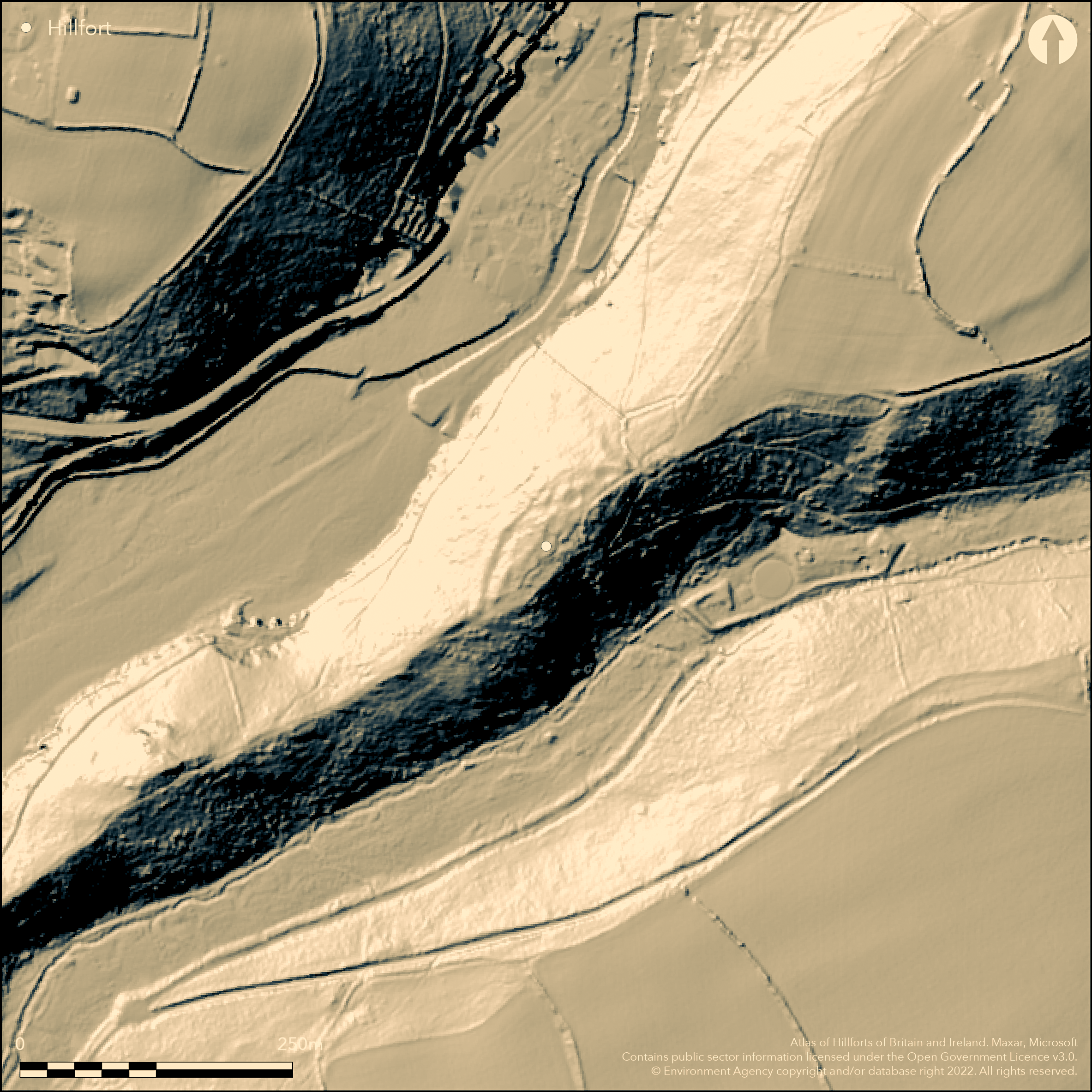
Partial contour hillfort sited on narrow spine of the Gribin ridge, 55m above sea level, c. 300m SW of Solva hillfort (Atlas No. 1984) and 500m NE of the Gribin Promontory fort (Atlas No. 1976) on the far tip of Solva Head. First recorded by Pembrokeshire Coast National Park in 2010, followed by aerial reconnaissance and detailed survey by RCAHMW. Steep to very steep slopes to E and W. Undulating along ridge to NE and SW. Roughly oval shape measuring c. 127m NE-SW by between 7m and 34m SE-NW. Area not defined. Defined by the steep natural slopes on E side and 4.5m wide terrace on W. No banks or ditches visible and palisade defence likely. Two opposing entrances likely at each end of the spine of the ridge on NE and SW. Main feature of the site are up to 20 platforms, probably providing foundations for structures of some sort. Most definitive examples survive as clear earthworks created through cutting into the sloping ground on W side, whilst on ridge top they are much shallower depressions cut into the bedrock. Under rough grass, gorse and scrub. Minimal investigations, undated.
Citizen Science: ✗
Reliability of Data: Confirmed
Reliability of Interpretation: Confirmed
X: -577551 Y: 6777193 (EPSG: 3857)
Longitude: -5.188232003077933 Latitude: 51.87299003781562 (EPSG:4326)
Country: Wales
Current County or Unitary Authority: Pembrokeshire
Historic County: Pembrokeshire
Current Parish/Community/Council/Townland: Solva
No banks visible, but interior platforms survive.
| Extant | ✓ |
| Cropmark | ✗ |
| Likely Destroyed | ✗ |
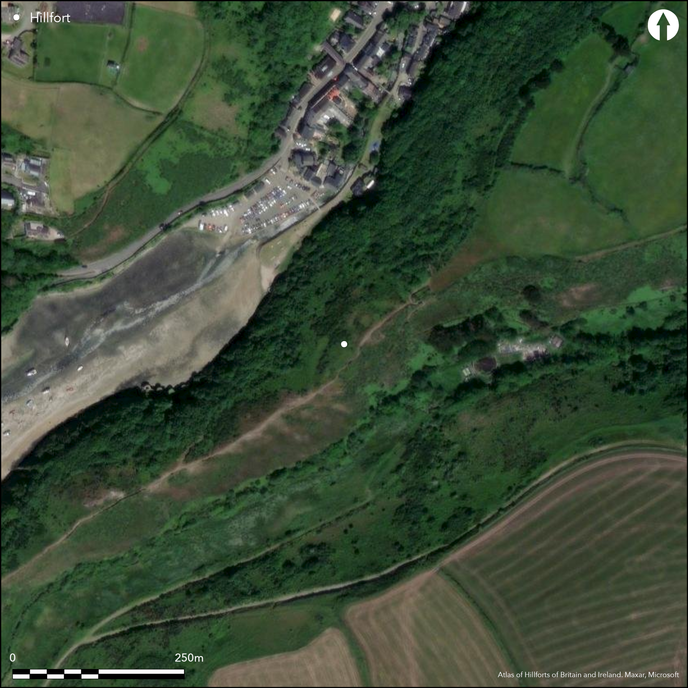
Under rough coastal grass, gorse and scrub.
| Woodland | ✗ |
| Commercial Forestry Plantation | ✗ |
| Parkland | ✗ |
| Pasture (Grazing) | ✗ |
| Arable | ✗ |
| Scrub/Bracken | ✓ |
| Bare Outcrop | ✗ |
| Heather/Moorland | ✗ |
| Heath | ✗ |
| Built-up | ✗ |
| Coastal Grassland | ✓ |
| Other | ✗ |
Partial contour hillfort sited on narrow spine of the Gribin ridge, 55m above sea level, c. 300m SW of Solva hillfort and 500m NE of the Gribin Promontory fort on the far tip of Solva Head. Steep to very steep slopes to E and W. Undulating along ridge to NE and SW.
| Contour Fort | ✗ |
| Partial Contour Fort | ✓ |
| Promontory Fort | ✗ |
| Hillslope Fort | ✗ |
| Level Terrain Fort | ✗ |
| Marsh Fort | ✗ |
| Multiple Enclosure Fort | ✗ |
| Hilltop | ✗ |
| Coastal Promontory | ✗ |
| Inland Promontory | ✗ |
| Valley Bottom | ✗ |
| Knoll/Hillock/Outcrop | ✗ |
| Ridge | ✓ |
| Cliff/Plateau-edge/Scarp | ✗ |
| Hillslope | ✗ |
| Lowland | ✗ |
| Spur | ✗ |
Dominant Topographic Feature: Ridge
| North | ✗ |
| Northeast | ✗ |
| East | ✗ |
| Southeast | ✗ |
| South | ✗ |
| Southwest | ✗ |
| West | ✗ |
| Northwest | ✗ |
| Level | ✓ |
Altitude: 55.0m
N/A
None
Reliability: D - None
| Pre 1200BC | ✗ |
| 1200BC - 800BC | ✗ |
| 800BC - 400BC | ✗ |
| 400BC - AD50 | ✗ |
| AD50 - AD400 | ✗ |
| AD400 - AD 800 | ✗ |
| Post AD800 | ✗ |
| Unknown | ✓ |
| Pre Hillfort: | None |
| Post Hillfort: | None |
First recorded by Pembrokeshire Coast National Park 2010, followed by later aerial reconnaissance and detailed survey by RCAHMW.
| 1st Identified Written Reference (2010): | First recorded by Pembrokeshire Coast National Park |
| Other (2011): | Visited by Hillfort Study Group |
| Other (None): | Aerial reconnaissance and detailed survey by RCAHMW. |
Main feature of the site are up to 20 platforms, probably providing foundations for structures of some sort. Most definitive examples survive as clear earthworks created through cutting into the sloping ground on W side, whilst on ridge top they are much shallower depressions cut into the bedrock.
None
| None | ✓ |
| Spring | ✗ |
| Stream | ✗ |
| Pool | ✗ |
| Flush | ✗ |
| Well | ✗ |
| Other | ✗ |
Main feature of the site are up to 20 platforms, probably providing foundations for structures of some sort. Most definitive examples survive as clear earthworks created through cutting into the sloping ground on W side, whilst on ridge top they are much shallower depressions cut into the bedrock
| No Known Features | ✗ |
| Round Stone Structures | ✗ |
| Rectangular Stone Structures | ✗ |
| Curvilinear Platforms | ✓ |
| Other Roundhouse Evidence | ✗ |
| Pits | ✗ |
| Quarry Hollows | ✗ |
| Other | ✗ |
None
| No Known Excavation | ✓ |
| Pits | ✗ |
| Postholes | ✗ |
| Roundhouses | ✗ |
| Rectangular Structures | ✗ |
| Roads/Tracks | ✗ |
| Quarry Hollows | ✗ |
| Other | ✗ |
| Nothing Found | ✗ |
None
| No Known Geophysics | ✓ |
| Pits | ✗ |
| Roundhouses | ✗ |
| Rectangular Structures | ✗ |
| Roads/Tracks | ✗ |
| Quarry Hollows | ✗ |
| Other | ✗ |
| Nothing Found | ✗ |
None
| No Known Finds | ✓ |
| Pottery | ✗ |
| Metal | ✗ |
| Metalworking | ✗ |
| Human Bones | ✗ |
| Animal Bones | ✗ |
| Lithics | ✗ |
| Environmental | ✗ |
| Other | ✗ |
NO APPARENT FEATURES
| APs Not Checked | ✓ |
| None | ✗ |
| Roundhouses | ✗ |
| Rectangular Structures | ✗ |
| Pits | ✗ |
| Postholes | ✗ |
| Roads/Tracks | ✗ |
| Other | ✗ |
Two opposing entrances likely at each end of the spine of the ridge on NE and SW.
| 2: | None |
| 2: | None |
Guard Chambers: ✗
Chevaux de Frise: ✗
| 1. Simple Gap (North east): | None |
| 2. Simple Gap (South west): | None |
Defined by the steep natural slopes on E side and 4.5m wide terrace on W. No banks or ditches visible and palisade defence likely.
| Area 1: | Noneha. |
| Total: | Noneha. |
Total Footprint Area: Noneha.
None
| ✗ | Area not defined - no sure limits. |
| ✗ | None |
| NE Quadrant: | 0 |
| SE Quadrant: | 0 |
| SW Quadrant: | 0 |
| NW Quadrant: | 0 |
| Total: | 0 |
| Partial Univallate | ✗ |
| Univallate | ✗ |
| Partial Bivallate | ✗ |
| Bivallate | ✗ |
| Partial Multivallate | ✗ |
| Multivallate | ✗ |
| Unknown | ✓ |
| Partial Univallate | ✗ |
| Univallate | ✗ |
| Partial Bivallate | ✗ |
| Bivallate | ✗ |
| Partial Multivallate | ✗ |
| Multivallate | ✗ |
No banks visible and palisade defence likely.
| None | ✗ |
| Earthen Bank | ✗ |
| Stone Wall | ✗ |
| Rubble | ✗ |
| Wall-walk | ✗ |
| Evidence of Timber | ✗ |
| Vitrification | ✗ |
| Other Burning | ✗ |
| Palisade | ✓ |
| Counter Scarp Bank | ✗ |
| Berm | ✗ |
| Unfinished | ✗ |
| Other | ✗ |
None
| None | ✗ |
| Earthen Bank | ✗ |
| Stone Wall | ✗ |
| Murus Duplex | ✗ |
| Timber-framed | ✗ |
| Timber-laced | ✗ |
| Vitrification | ✗ |
| Other Burning | ✗ |
| Palisade | ✗ |
| Counter Scarp Bank | ✗ |
| Berm | ✗ |
| Unfinished | ✗ |
| No Known Excavation | ✓ |
| Other | ✗ |
| ✗ | None |
| ✗ | None |
Number of Ditches: 0
| ✗ | None |
No related records
Atlas of Hillforts:
Wikidata:
This work is licensed under CC BY-SA 4.0![]()
![]()
![]() and should be cited as:
and should be cited as:
Lock, Gary and Ralston, Ian. 2024. Atlas of Hillforts of Britain and Ireland. Available at: https://hillforts.arch.ox.ac.uk
Document Version 1.1