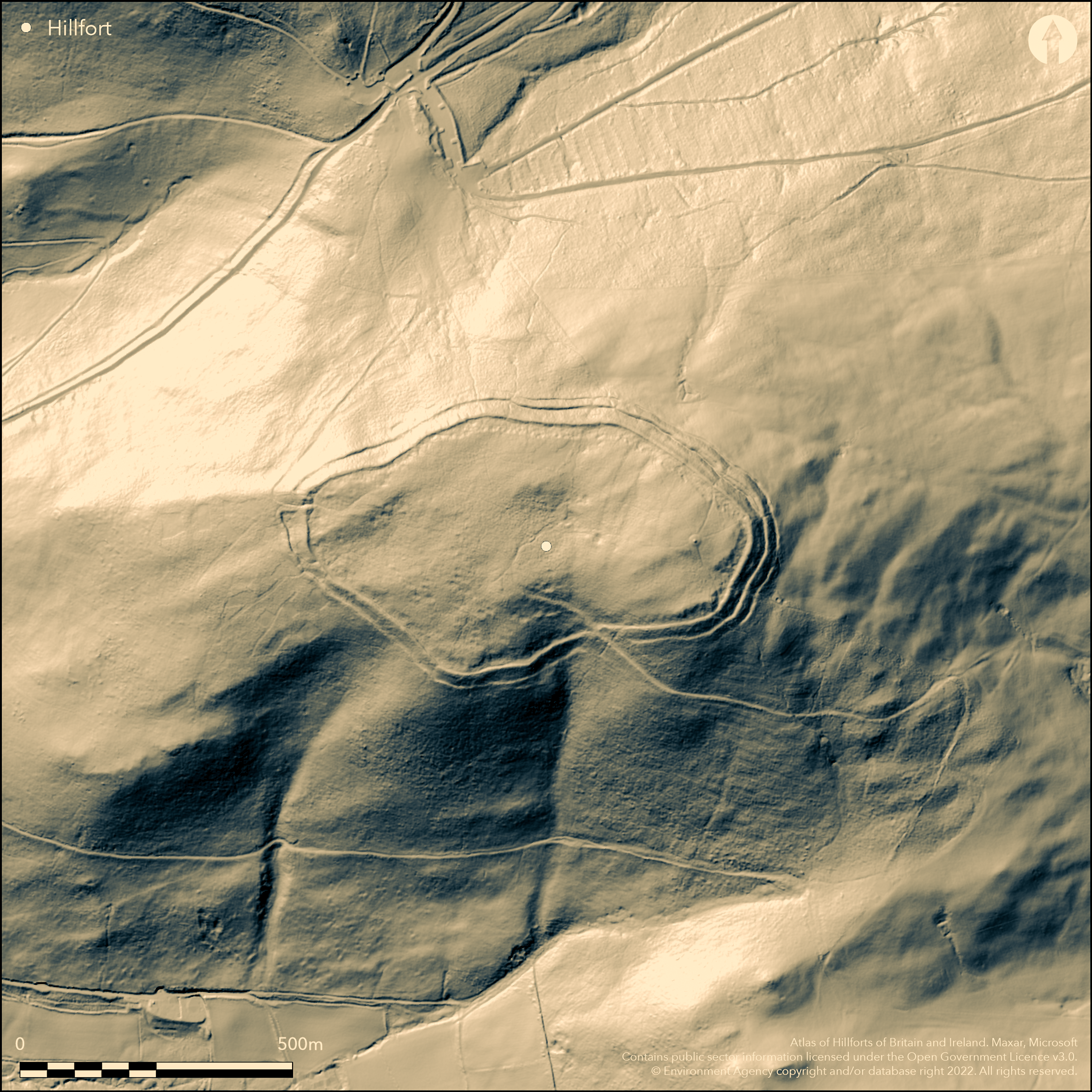
LiDAR 1m DTM Hillshade
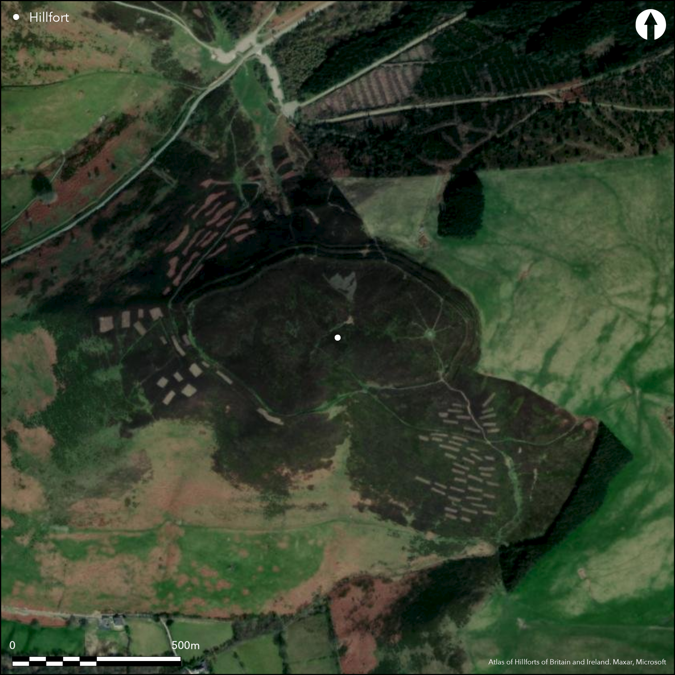
Satellite Imagery
LiDAR 1m DTM Hillshade
Satellite Imagery
Scroll left/right to view further images.
HER: Clwyd Powys 102311 (None)
NMR: SJ 16 SE (96522)
SM: DE009
NGR: SJ1632060080
X: 316320 Y: 360080 (OSGB36)
Large, high, and exposed multivallate partial contour hillfort located high above Bwlch Pen Barras pass and Vale of Clwyd; the southern-most hillfort in the Clwydian Range. Very steep surrounding slopes, less on E. Site tilted across the contours towards the vale. Roughly oval shaped, measures c. 480m E-W by 74-280m, with internal area 9.5ha. Strong massive ramparts, particularly on the N and NE, with two banks and ditches, counterscarp and quarry ditch. Fine inturned entrance on W. Bronze Age cairn of 16m diameter at the summit and 61 hut platforms identified. Diagonal path from below from the N may be original. Unlike most hillforts site well supplied with water with spring on site. 1840's 'excavation' by Rev Wynne Ffoulkes found Roman pottery, possibly linked to two hoards of late Roman coins found 1816 and 1847. Possible excavation by M. Bevan Evans in 1960's but no record. Hillfort constituent part of the Heather and Hillforts Landscape Partnership Scheme, funded by the Heritage Lottery fund of Denbighshire County Council 2006-2011, included topographical survey, interpretation and visitor management works. Heather moorland. On 1st Ed. OS map (1882-74).
Citizen Science: ✗
Reliability of Data: Confirmed
Reliability of Interpretation: Confirmed
X: -362031 Y: 7007317 (EPSG: 3857)
Longitude: -3.252176516620174 Latitude: 53.13127395722238 (EPSG:4326)
Country: Wales
Current County or Unitary Authority: Denbighshire
Historic County: Denbighshire
Current Parish/Community/Council/Townland: Llanbedr Dyffryn Clwyd
Owned by Denbishire County Council as part of Moel Famau Country Park. Fine condition and well managed. Active visitor management. Offa's Dyke Path skirts site.
| Extant | ✓ |
| Cropmark | ✗ |
| Likely Destroyed | ✗ |
Managed heather moorland. SSSI.
| Woodland | ✗ |
| Commercial Forestry Plantation | ✗ |
| Parkland | ✗ |
| Pasture (Grazing) | ✗ |
| Arable | ✗ |
| Scrub/Bracken | ✗ |
| Bare Outcrop | ✗ |
| Heather/Moorland | ✓ |
| Heath | ✗ |
| Built-up | ✗ |
| Coastal Grassland | ✗ |
| Other | ✗ |
Large high and exposed partial contour hillfort located high above Bwlch Pen Barras pass and Vale of Clwyd on the Clwydian Range. Very steep surrounding slopes, less on E. Site tilted across the contours towards the vale.
| Contour Fort | ✗ |
| Partial Contour Fort | ✓ |
| Promontory Fort | ✗ |
| Hillslope Fort | ✗ |
| Level Terrain Fort | ✗ |
| Marsh Fort | ✗ |
| Multiple Enclosure Fort | ✗ |
| Hilltop | ✓ |
| Coastal Promontory | ✗ |
| Inland Promontory | ✗ |
| Valley Bottom | ✗ |
| Knoll/Hillock/Outcrop | ✗ |
| Ridge | ✗ |
| Cliff/Plateau-edge/Scarp | ✗ |
| Hillslope | ✗ |
| Lowland | ✗ |
| Spur | ✗ |
Dominant Topographic Feature: Hill top
| North | ✗ |
| Northeast | ✗ |
| East | ✗ |
| Southeast | ✗ |
| South | ✗ |
| Southwest | ✗ |
| West | ✓ |
| Northwest | ✗ |
| Level | ✗ |
Altitude: 511.0m
N/A
None.
Reliability: D - None
| Pre 1200BC | ✗ |
| 1200BC - 800BC | ✗ |
| 800BC - 400BC | ✗ |
| 400BC - AD50 | ✗ |
| AD50 - AD400 | ✗ |
| AD400 - AD 800 | ✗ |
| Post AD800 | ✗ |
| Unknown | ✓ |
| Pre Hillfort: | Bronze Age cairn on summit. |
| Post Hillfort: | Roman coin hoards found 1816, 1847. Samian ware Roman pottery found in 1840's diggings. |
| Artefactual: | Roman coin hoard and pottery. |
On 1st Ed. OS map (1882-74). 'Excavation' by Rev Wynne Ffoulkes in 1849/50. Possible excavation by Bevan Evans in 1960's but no record. Hillfort constituent part of the Heather and Hillforts Landscape Partnership Scheme, funded by the Heritage Lottery fund of Denbighshire County Council 2006-2011, included topographical survey, interpretation and visitor management works.
| Other (2012): | Visited by Hillfort Study Group |
| Excavation (None): | Rev Wynne Ffoulkes |
| 1st Identified Map Depiction (None): | OS map. |
| Excavation (None): | Possible excavation by M. Bevan Evans - no record. |
| Other (None): | Heather and Hillforts Landscape Partnership Scheme, Denbighshire County Council. |
Hut platforms visible despite heather cover and 61 hut platforms identified by topographical survey. Quarry ditch visible. Roman pottery found in 1840's diggings. Two Roman coin hoards found 1816 and 1847.
Spring on site.
| None | ✗ |
| Spring | ✓ |
| Stream | ✗ |
| Pool | ✗ |
| Flush | ✗ |
| Well | ✗ |
| Other | ✗ |
Hut platforms visible despite heather cover and 61 hut platforms identified by topographical survey. Quarry ditch visible around circuit.
| No Known Features | ✗ |
| Round Stone Structures | ✗ |
| Rectangular Stone Structures | ✗ |
| Curvilinear Platforms | ✓ |
| Other Roundhouse Evidence | ✗ |
| Pits | ✗ |
| Quarry Hollows | ✓ |
| Other | ✗ |
None
| No Known Excavation | ✗ |
| Pits | ✗ |
| Postholes | ✗ |
| Roundhouses | ✗ |
| Rectangular Structures | ✗ |
| Roads/Tracks | ✗ |
| Quarry Hollows | ✗ |
| Other | ✗ |
| Nothing Found | ✓ |
None
| No Known Geophysics | ✓ |
| Pits | ✗ |
| Roundhouses | ✗ |
| Rectangular Structures | ✗ |
| Roads/Tracks | ✗ |
| Quarry Hollows | ✗ |
| Other | ✗ |
| Nothing Found | ✗ |
Roman pottery, including Samian ware, found in 1840's diggings, possibly linked to Roman coin hoards found earlier 1816,1847.
| No Known Finds | ✗ |
| Pottery | ✓ |
| Metal | ✗ |
| Metalworking | ✗ |
| Human Bones | ✗ |
| Animal Bones | ✗ |
| Lithics | ✗ |
| Environmental | ✗ |
| Other | ✓ |
None
| APs Not Checked | ✓ |
| None | ✗ |
| Roundhouses | ✗ |
| Rectangular Structures | ✗ |
| Pits | ✗ |
| Postholes | ✗ |
| Roads/Tracks | ✗ |
| Other | ✗ |
Inturned W entrance with possible outworks, that on S possibly modern. Diagonal path from below from the N may be original.
| 2: | Gap on S possible modern. |
| 2: | None |
Guard Chambers: ✗
Chevaux de Frise: ✗
| 1. In-turned (West): | Possible outworks. |
| 1. Outworks (West): | Possible outworks. |
Strong massive ramparts, particularly on the N and NE, with two banks and ditches, counterscarp and quarry ditch.
| Area 1: | 9.5ha. |
| Total: | 9.5ha. |
Total Footprint Area: Noneha.
None
| ✗ | None |
| ✓ | None |
| NE Quadrant: | 2 |
| SE Quadrant: | 2 |
| SW Quadrant: | 2 |
| NW Quadrant: | 2 |
| Total: | 2 |
| Partial Univallate | ✗ |
| Univallate | ✗ |
| Partial Bivallate | ✗ |
| Bivallate | ✓ |
| Partial Multivallate | ✗ |
| Multivallate | ✗ |
| Unknown | ✗ |
| Partial Univallate | ✗ |
| Univallate | ✗ |
| Partial Bivallate | ✗ |
| Bivallate | ✗ |
| Partial Multivallate | ✗ |
| Multivallate | ✗ |
None
| None | ✗ |
| Earthen Bank | ✓ |
| Stone Wall | ✗ |
| Rubble | ✗ |
| Wall-walk | ✗ |
| Evidence of Timber | ✗ |
| Vitrification | ✗ |
| Other Burning | ✗ |
| Palisade | ✗ |
| Counter Scarp Bank | ✓ |
| Berm | ✗ |
| Unfinished | ✗ |
| Other | ✗ |
None
| None | ✗ |
| Earthen Bank | ✗ |
| Stone Wall | ✗ |
| Murus Duplex | ✗ |
| Timber-framed | ✗ |
| Timber-laced | ✗ |
| Vitrification | ✗ |
| Other Burning | ✗ |
| Palisade | ✗ |
| Counter Scarp Bank | ✗ |
| Berm | ✗ |
| Unfinished | ✗ |
| No Known Excavation | ✓ |
| Other | ✗ |
| ✗ | None |
| ✓ | None |
Number of Ditches: 2
| ✗ | None |
Brown, I. 2004. Discovering a Welsh landscape. Archaeology in the Clwydian Range, Oxford: Windgather Press.
Burnham, H. 1995. A guide to ancient and historic Wales, London: HMSO, 59-61.
Davies, Canon Ellis 1929. The Prehistoric and Roman remains of Denbighshire, Cardiff: William Lewis, 183-6, 228.
Driver,T. 2011. The Hillforts, In ed Mrowiec, H., Heather and Hillforts of the Clwydian Range and Llantysilio Mountains, Ruthin: Heather and Hillforts Partnership Board, Denbighshire County Council.
Wynne Ffoulkes, Rev. W. 1850. Castra Clwydiana No. I. Moel Fenlli, Arch Camb, New Series, I, 81-9.
Davies, Canon Ellis 1929. The Prehistoric and Roman remains of Denbighshire, Cardiff: William Lewis, 183-6, 228.
Atlas of Hillforts:
Wikidata:
This work is licensed under CC BY-SA 4.0

 and should be cited as:
Lock, Gary and Ralston, Ian. 2024. Atlas of Hillforts of Britain and Ireland. Available at: https://hillforts.arch.ox.ac.uk
Document Version 1.1